

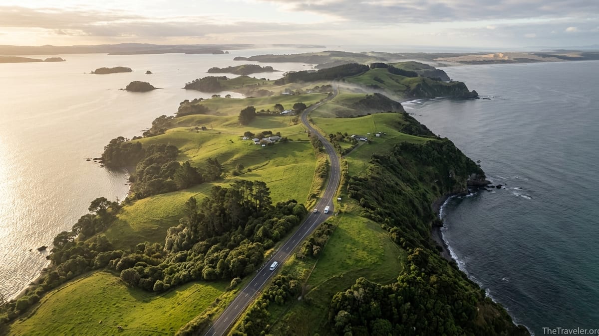
The Twin Coast Discovery Highway is Northland’s signature road trip, an approximately 800 kilometre circuit linking Auckland with Whangārei, the Bay of Islands, the Far North, Hokianga and the Kauri Coast. Designed as a self-drive touring route, it lets you experience two very different coasts, ancient kauri forests and some of Aotearoa New Zealand’s most important cultural sites in a single loop. This guide breaks the journey into logical overnight bases, explains where to cross from one coast to the other, and offers practical tips on driving times, fuel, detours and how to shorten the route if you are tight on time.
Understanding the Twin Coast Discovery Highway
The Twin Coast Discovery Highway is a long-established visitor route in Te Tai Tokerau Northland. Regional and national tourism agencies describe it as an 800 kilometre circular journey that follows State Highways 1, 10, 11, 12 and 16 from Auckland around both the east and west coasts before looping back south. Rather than a separate road, it is a wayfinding concept that stitches together existing highways into a coherent touring circuit, with brown tourist signs and consistent branding to help drivers follow the loop.
Tourism New Zealand promotes the Twin Coast Discovery as the main touring route for Northland, often suggested as a six day itinerary of roughly 695 kilometres for those starting and finishing in Auckland. Regional tourism information in Northland emphasizes the full 800 kilometre circuit, which assumes some side trips to coastal settlements, forest walks and viewpoints along the way. In practice, most visitors will cover somewhere between these distances depending on their choice of detours.
The route can be driven in any direction, but many travelers find it easiest to start in Auckland, head to Whangārei, continue up the east coast through the Bay of Islands and the Far North to Te Rerenga Wairua Cape Reinga, then return south via Hokianga, the Kauri Coast and State Highway 16 back into Auckland. This pattern suits both international arrivals landing at Auckland Airport and domestic visitors collecting a rental car in the city.
It is possible to race through the loop in three days, but the design of the route, and the distances involved, reward a slower pace. A comfortable circuit for first-time visitors usually involves five to eight days, depending on how long you want to spend in the Bay of Islands and the Far North. The following sections break the journey into practical legs with realistic drive times and suggested overnight stops.
Auckland to Whangārei: Gateway to Northland
The southern gateway to the Twin Coast Discovery Highway is Auckland, New Zealand’s largest city. From central Auckland to Whangārei, Northland’s main city, is around 160 kilometres by road. Under normal conditions, it takes about two hours to drive this leg via State Highway 1, not counting traffic delays leaving Auckland at peak commuter times. Regional drive-time maps used by Northland tourism operators commonly quote “Auckland to Whangārei – 2 hrs” as a planning figure, which is realistic for most travelers.
Most itineraries treat this stretch as a transit leg, but it is worth planning at least one break. Warkworth offers fuel, supermarkets and cafes within an hour of leaving Auckland. Further north, Waipu and Waipu Cove are easy detours for a beach walk or fish and chips. If you have an extra night, stopping at Mangawhai Heads or Waipu breaks up the journey before you cross into Northland proper.
Whangārei itself is more than a refuelling stop. The compact city centre has supermarkets, petrol stations, motels and holiday parks that make it a convenient first-night base. The rejuvenated Town Basin waterfront concentrates cafes, public art and the Hundertwasser Art Centre, while the nearby Whangārei Falls are a short drive and easy 20 to 30 minute loop walk. If you plan to explore the Tutukaka Coast or Poor Knights Islands on a dive or snorkelling trip, it often makes sense to stay two nights in Whangārei or in Tutukaka, using a full day on the water.
Road conditions on this leg are straightforward. State Highway 1 north of Auckland is a mix of motorway and standard two lane highway. There are regular fuel stops, including Wellsford, Warkworth and Ruakākā, so there is no need to stockpile petrol here. However, planning your departure to avoid Auckland’s weekday rush hours can easily save 30 to 45 minutes at the start of your trip.
Whangārei to Bay of Islands: Beaches and History
From Whangārei to Paihia in the Bay of Islands is roughly 80 to 90 kilometres depending on your exact route. Many visitors simply follow State Highway 1 to Kawakawa and then State Highway 11 to Paihia, which typically takes between one and a half and two hours of driving. Regional travel maps often state “Auckland to Paihia – 3 hrs,” so from Whangārei you can think in terms of about an hour less than that.
The Bay of Islands is the natural place to settle in for two or three nights. Paihia works well as a base because it has a dense concentration of accommodation, from simple motels and holiday parks through to mid-range seaside hotels. Russell, across the bay, offers a quieter village feel with heritage buildings and boutique guesthouses. Kerikeri, about 25 minutes inland from Paihia, gives access to orchards, wineries and historic sites like the Stone Store while still being within easy reach of the coast.
A typical travel day might involve leaving Whangārei after breakfast, stopping in Kawakawa to see the town’s distinctive public toilets designed by Friedensreich Hundertwasser and perhaps grabbing coffee from a local bakery. From there, it is less than an hour to the Bay of Islands. With an early start, it is realistic to reach Paihia in time for a midday harbour cruise or an afternoon visit to the Waitangi Treaty Grounds, one of New Zealand’s most important historic sites, where admission tickets commonly include both museum entry and guided tours.
This section of the Twin Coast Discovery Highway is also where you can begin to adjust your route according to interests. Divers and snorkellers may add an extra night to reach Tutukaka for trips to the Poor Knights Islands marine reserve. Families might choose a more relaxed schedule, with a half day cruise around the islands and time on the beach at Paihia or Russell. The roads remain sealed and relatively straightforward, but summer holidays and long weekends can bring heavy traffic, so build in a little slack around departure and check for any roadworks before you leave.
Bay of Islands to the Far North and Te Rerenga Wairua Cape Reinga
North of the Bay of Islands, the Twin Coast Discovery Highway splits into two main options: State Highway 1 inland via Kawakawa and Kaitaia, and State Highway 10 which hugs more of the east coast through places like Coopers Beach and Mangonui before rejoining State Highway 1 south of Kaitaia. Many travelers drive up one way and return the other. The distance from Paihia to Kaitaia is roughly 120 to 140 kilometres depending on route choice, and takes around two to two and a half hours of pure driving.
Most people use Kaitaia as their main base in the Far North. It is the northernmost significant town in New Zealand, with supermarkets, multiple petrol stations, mechanics and a range of motels and holiday parks. Its location makes it a practical starting point for day tours to Te Rerenga Wairua Cape Reinga and Te Paki sand dunes, particularly for visitors who prefer not to drive the final narrow roads themselves. Alternatively, some travelers choose to spend a night closer to the end of the road at smaller places such as Pukenui on Houhora Harbour, which offers holiday parks and simple motels in a quieter setting.
From Kaitaia to Te Rerenga Wairua Cape Reinga via State Highway 1 is just over 110 kilometres one way. While the road is sealed, it is mostly two lane highway with frequent curves and some steep sections. In clear conditions, expect around one hour and forty minutes to two hours each way, not including stops. Many visitors allow at least a full day for the return trip, giving time to climb the Te Paki sand dunes with rented bodyboards, walk to the lighthouse at Cape Reinga, and spend an hour on nearby beaches such as Tapotupotu Bay or Spirits Bay.
Fuel planning becomes more important in this area. Kaitaia is the last major service centre, and it is wise to fill your tank there even if you are only half empty. There are smaller fuel outlets at places like Pukenui and Waitiki Landing, but they may have shorter opening hours or limited services, especially outside peak seasons. Rental car contracts commonly prohibit driving on the sand of Ninety Mile Beach, so even though coach tours regularly use the beach as a highway, self-drive visitors should stay on sealed roads unless their vehicle and insurance explicitly allow off-road travel.
Crossing to the West: Hokianga, Kauri Forests and the Kauri Coast
After visiting the Far North, the Twin Coast Discovery Highway invites you to cross from the east coast to the west coast and begin the return journey via Hokianga and the Kauri Coast. The logical place to do this is between the Bay of Islands or Kaitaia and Hokianga Harbour. One popular pattern is to drive south from Kaitaia via State Highway 1 through the Mangamuka area, then divert west at the junction near Okaihau or Kaikohe towards Ōmāpere and Opononi on Hokianga Harbour. Travel information used by regional tourism operators suggests that Auckland to Hokianga is roughly three hours forty five minutes of driving, which aligns with a Kaitaia to Hokianga leg of around two to three hours depending on stops.
Ōmāpere and Opononi make excellent overnight bases. These twin settlements sit on opposite sides of a small headland overlooking Hokianga Harbour with sweeping sand dunes across the water. Accommodation ranges from small motels on the waterfront to simple holiday homes and a well known hotel in Ōmāpere that offers sunset views over the harbour. This is a good place to slow down for a night, walk along the beach, or take a harbour cruise with dune boarding excursions when available.
From Hokianga, the route continues south into Waipoua Forest along State Highway 12. This winding, scenic road is where many travelers encounter New Zealand’s remaining stands of ancient kauri trees. Short walks lead into the forest to Tāne Mahuta, often described as the largest known living kauri, and to other giant trees. Parking areas are signposted, but spaces can be tight for larger campervans during busy periods, so arriving early or later in the day can be helpful. Good walking shoes and respect for kauri dieback cleaning stations at track entrances are essential.
Continuing south, you emerge from the forest onto the Kauri Coast proper, with Dargaville as the largest town. Along the way, side trips lead to the long, straight sands of Ripiro Beach near Baylys Beach, sometimes claimed to be the longest drivable beach in New Zealand, and to the clear freshwater Kai Iwi Lakes, popular for swimming and kayaking in summer. At least one night in this area, whether in Dargaville, at the lakes or at Baylys Beach, helps break the journey before the final return to Auckland.
Dargaville, State Highway 16 and Returning to Auckland
From Dargaville, the Twin Coast Discovery Highway gives you two main ways back to Auckland. The more inland route follows State Highway 14 to Whangārei and then State Highway 1 south, effectively rejoining part of your northbound path. The more scenic coastal return joins State Highway 12 south and then State Highway 16 through rural countryside and along the Kaipara Harbour edge before entering Auckland’s western suburbs. State Highway 16 is recognised nationally as part of the Twin Coast Discovery Highway and offers a quieter alternative to parts of State Highway 1.
The drive from Dargaville to central Auckland via State Highway 16 is roughly 190 to 220 kilometres and usually takes about three and a half to four hours of driving in normal conditions. Matakohe, home to a well regarded kauri museum, is an excellent mid-morning or afternoon stop, both for the exhibition and the on-site cafe. Further south, Helensville marks your re-entry into the wider Auckland region, where suburban traffic becomes heavier and speeds drop.
Fuel availability on this leg is generally good, with service stations in Dargaville, Ruawai, Wellsford and closer to Auckland. However, some stretches of State Highway 16 feel quite rural, and it is sensible to keep your tank above one quarter full. Cellular reception is mostly reliable but may be patchy in forested or hilly sections. Simple precautions, such as checking weather forecasts and road condition reports before you leave Dargaville, will help avoid surprises from road works or heavy rain.
For travelers flying out of Auckland, it is normally unwise to combine this drive with a same-day long-haul flight departure, particularly if you have a rental vehicle to return. A safer plan is to spend your final night somewhere in the greater Auckland area or at an airport hotel, allowing generous time for traffic delays and formalities the following day.
Shortening the Circuit: Practical Variations
Not every visitor has time for the full 800 kilometre loop. Fortunately, the Twin Coast Discovery Highway is flexible, and you can trim or adapt it without losing the character of the journey. Tourism New Zealand commonly promotes a six day version that covers key highlights, but even four days can work if you concentrate on one coast and limit backtracking.
The simplest way to shorten the route is to focus on the east coast and treat the west coast as an optional extra. For example, a four day itinerary might look like this: Auckland to Bay of Islands on day one, a full day in the Bay of Islands, a long day trip to Te Rerenga Wairua Cape Reinga and back to Kaitaia or the Bay of Islands on day three, and return to Auckland on day four via State Highway 1. This version omits Hokianga and the Kauri Coast but still includes beaches, history and the Far North experience.
Another practical shortcut is to cross the island only once instead of making a full loop. You might drive north on the east coast to the Bay of Islands and Far North, then cross to Hokianga and Waipoua Forest and finally return to Auckland via Whangārei or State Highway 16, skipping some of the small coastal detours. This reduces duplicating stretches of highway while keeping both coasts in your trip. For travelers with five days, spending two nights in the Bay of Islands, one night in the Far North and one night in Hokianga or on the Kauri Coast strikes a good balance.
Visitors who are very short on time, such as those with three days starting and ending in Auckland, may choose a loop limited to the western side of the Twin Coast Discovery Highway. In this scenario, you could drive from Auckland via State Highway 16 to Dargaville and on to Hokianga, spend a night in Ōmāpere or Opononi, explore Waipoua Forest and the Kai Iwi Lakes the next day, then return to Auckland. This avoids the long haul to Cape Reinga while still delivering ancient forest, harbour scenery and coastal landscapes.
Driving Conditions, Fuel and Seasonal Considerations
Although the Twin Coast Discovery Highway is a promoted touring route, the roads themselves are mostly standard New Zealand state highways: generally two lanes, one in each direction, with occasional passing lanes and some winding sections. North of Whangārei, expect narrower carriageways, tighter curves, frequent speed limit changes and occasional logging or freight trucks. The Mangamuka area and the sections through Waipoua Forest, in particular, involve twisty climbs and descents where cautious speeds are advisable, especially in wet conditions.
Driving times quoted in this guide reflect typical regional estimates but can vary with weather, holiday traffic and construction work. A common mistake is to assume that 100 kilometres will always take exactly an hour. On the Twin Coast Discovery Highway, it is safer to assume average speeds closer to 70 to 80 kilometres per hour once you are north of Whangārei, particularly if you are in a campervan or towing a trailer. Planning no more than four to five hours of total driving on any given day leaves room for rest stops and sightseeing.
Fuel is generally available in all significant towns, including Whangārei, Kawakawa, Paihia, Kerikeri, Kaitaia, Dargaville and Helensville. However, convenience can drop sharply once you move into sparsely populated stretches. Many travelers treat Whangārei, Kerikeri and Kaitaia as key refuelling points and top up even if their tank is half full before heading into more remote areas like the Far North or Waipoua Forest. Paying with credit or debit cards at unattended pumps may be necessary at smaller stations, and some independent outlets have reduced hours on weekends or holidays.
Weather in Northland is usually milder than much of the country, but heavy rain can still cause localised surface flooding or slips, especially on hill roads and through bush-clad gorges. Winter driving brings shorter daylight hours and can mean leaving after dawn and ending the day before dark is a safer and more scenic choice. In peak summer, the main constraints are heat, high visitor numbers in popular towns and limited last-minute accommodation. Booking ahead for Bay of Islands and Hokianga stays over Christmas and school holiday periods is strongly recommended, especially for larger vehicles that need powered campsites.
The Takeaway
The Twin Coast Discovery Highway is more than just a marketing label. It is a practical framework for exploring Northland by car, knitting together some of New Zealand’s most appealing coastal scenery, forest, and cultural sites into an achievable loop. With an approximately 800 kilometre circuit promoted by Northland’s tourism authorities and a shorter six day version advocated by Tourism New Zealand, there is enough flexibility to match the route to your available time and interests.
By breaking the journey into sensible legs between Auckland, Whangārei, the Bay of Islands, the Far North, Hokianga and the Kauri Coast, you can plan realistic drive times, logical overnight bases and meaningful detours. Fuel planning, awareness of typical road conditions and a conscious decision about where to cross between coasts all help remove stress and allow the landscapes and stories of Te Tai Tokerau Northland to take centre stage.
Whether you commit to the full loop or adapt a shorter version, the key is to build in slack. Allow time to linger on a beach, to walk quietly among kauri in Waipoua Forest, or to stand at Te Rerenga Wairua Cape Reinga watching the meeting of the seas. The Twin Coast Discovery Highway is designed to be discovered at a human pace, and those who slow down generally find the route lives up to its name.
FAQ
Q1. How many days do I need to drive the Twin Coast Discovery Highway?
Most travelers find five to eight days comfortable for the full circuit starting and ending in Auckland. It is possible to compress a version of the route into four days by focusing on either the east or west coast, but this usually means less time for activities and more time in the car.
Q2. Where is the best place to base myself in the Bay of Islands?
Paihia is the most convenient base for many visitors because it offers a wide range of accommodation, tour departures and dining. Russell is a quieter, more historic option across the bay, accessed by ferry, while Kerikeri suits travelers who prefer a small town with orchards, vineyards and easy access to coastal day trips.
Q3. Is it realistic to visit Te Rerenga Wairua Cape Reinga as a day trip from the Bay of Islands?
It is technically possible but makes for a long day. The return journey from Paihia to Cape Reinga is often seven to eight hours of driving plus sightseeing stops. Many visitors prefer to stay a night in or near Kaitaia or Pukenui, reducing driving time on the day they visit the cape.
Q4. Do I need a four wheel drive vehicle for the Twin Coast Discovery Highway?
No, the main route uses sealed state highways that are suitable for standard two wheel drive cars and campervans. A four wheel drive is only necessary if you plan to drive on unsealed beaches or remote side roads, which many rental contracts specifically prohibit, especially on Ninety Mile Beach.
Q5. When is the best time of year to drive the route?
Northland has a relatively mild climate year-round, but many visitors favour late spring and early autumn for a balance of warm temperatures, longer daylight and lighter traffic. Summer holidays around late December and January bring the biggest crowds and highest accommodation demand, while winter offers quieter roads but shorter days.
Q6. Are there enough fuel stops, or should I carry spare fuel?
There are regular service stations in all main towns on the route, including Whangārei, Kerikeri, Kaitaia and Dargaville, so most travelers do not need to carry spare fuel. It is still wise to top up before remote sections, particularly north of Kaitaia or when heading into Waipoua Forest, to avoid unnecessary stress.
Q7. Is it safe and practical to drive the route in a motorhome?
Yes, many visitors use motorhomes or campervans on the Twin Coast Discovery Highway. Some forest and gorge sections are narrow and winding, so extra care with speed and cornering is important. Booking powered sites in advance for popular spots such as Paihia, Hokianga and the Kauri Coast is recommended in peak months.
Q8. How do I decide where to cross from the east coast to the west coast?
A common approach is to drive north on the east coast to the Bay of Islands and the Far North, then cross west via Kaikohe or Okaihau towards Hokianga Harbour. This pattern gives you time on both coasts without excessive backtracking and lines you up naturally to continue south through Waipoua Forest and the Kauri Coast.
Q9. Can I skip parts of the loop without missing the essence of the route?
Yes. Many short itineraries skip either the Far North or the Kauri Coast. Focusing on Auckland, the Bay of Islands and Hokianga still delivers beaches, history and ancient forest, while an east coast only trip centred on the Bay of Islands and Far North highlights marine and coastal experiences.
Q10. Do I need to book accommodation in advance along the route?
Outside peak holiday periods, you can often find same-day accommodation in larger centres such as Whangārei, Paihia and Kaitaia. However, for travel during school holidays, long weekends or between late December and January, advance bookings are strongly advised, especially for smaller coastal settlements and popular holiday parks.