


The Lake Marian Track in Fiordland has a split personality. For the first few minutes it feels like a gentle family stroll to a pretty waterfall. Very quickly after that, it turns into a steep, muddy, root-tangled climb to an alpine lake in a hanging valley, officially graded as an advanced tramping track by New Zealand’s Department of Conservation. What follows is a ground-level account of what that full hike to Lake Marian genuinely feels like, based on current track conditions and the latest guidance from DOC, rather than the filtered perfection of Instagram.
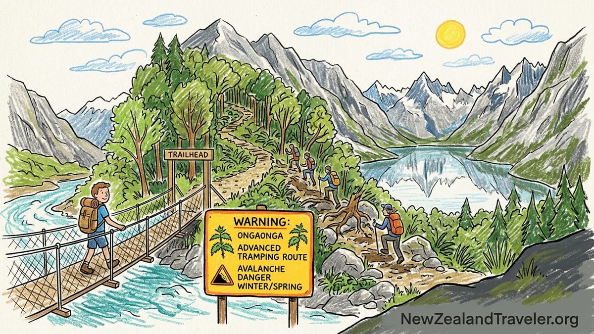
Getting to the Trailhead and Understanding the DOC Warnings
The Lake Marian Track starts from a small car park on Lower Hollyford Road, about 1 kilometre off the Milford Road in Fiordland National Park. The road is unsealed but usually passable in a standard rental car, although there are potholes that feel sharper after days of rain. DOC signage at the car park makes two things clear: Lake Marian is an alpine lake in a hanging valley, and the track beyond the waterfall section is classed as an advanced tramping route, roughly 3.1 kilometres one way with a recommended one and a half hours up for fit walkers. For many visitors who have just stepped off a comfortable Milford Sound cruise, that grading can come as a surprise.
DOC also highlights a hazard that overseas visitors often underestimate: ongaonga, or New Zealand tree nettle. There are prominent warnings that ongaonga is present along parts of the track, and that touching it can cause intense stinging, welts, and in rare cases more serious reactions. There is additional seasonal messaging about avalanches, including a clear instruction not to walk around the lake edge during the winter and spring avalanche season, when debris can slide straight off the cliffs and through the boulder fields that fringe the water. These are not theoretical risks in Fiordland’s steep, glaciated terrain.
Recent DOC updates have also noted temporary closures for construction and safety work on the track and viewing platforms near the falls, a reminder that this has rapidly shifted from a relatively quiet local favourite to one of the most visited day walks off the Milford Road. Before driving out, it is important to check the latest DOC notices or ask at the Fiordland National Park Visitor Centre in Te Anau, because closures can be put in place after heavy rain, slips, or infrastructure work and may extend over several months.
At the trailhead itself, the contrast between the neat car park, a basic DOC toilet, and the intimidating route descriptions can feel odd. On a clear morning you will likely see a mix of cautious trampers tightening boot laces, and casual sightseers in white sneakers planning to “just see how far we get.” The first ten minutes to the waterfall viewing gantry are exactly the kind of walk that lulls the second group into overconfidence.
The Easy First Ten Minutes to Marian Falls
From the car park, the track crosses a sturdy suspension bridge over the Hollyford River, a fast turquoise flow that feels quintessentially Fiordland. The bridge itself is stable and well maintained, with sturdy mesh underfoot and wire sides high enough that even those nervous about heights tend to relax by the midpoint. Looking down, you can sometimes see pale boulders under the clear water, giving an early indication of how powerful the river must be after heavy rain.
On the far side of the bridge the track is wide, benched, and gravelled. It threads through lush temperate rainforest thick with moss, ferns, and silver beech. This section is essentially a short nature walk suitable for most abilities. After about ten minutes at a relaxed pace, the track reaches a fenced viewing gantry above Marian Falls, where Marian Creek funnels into frothing cascades between house-sized boulders. DOC built this platform to cope with increasing visitor numbers and to keep people away from slippery rock edges right beside the water.
On a dry morning, the walk to the gantry feels almost effortless. Children in gumboots run ahead, older visitors in loafers lean on the railings, and tour vans arrive and depart in quick cycles. If you were to turn around at the falls, you would probably tell friends you had done the Lake Marian Track and found it “pretty easy.” Yet this short section is not representative of the rest of the route. Beyond the gantry, a narrow tramping track cuts away from the safety fencing and quickly reveals why DOC does not classify the whole track as a casual walk.
DOC and local operators now often describe the waterfall section as a separate experience from the Lake Marian climb. Some Milford Road tour itineraries even sell a “Marian Falls walk” as a short stop, with instructions not to continue past the gantry because of time and fitness limitations. That distinction is important for planning. Everything changes within a few footsteps once you leave the manicured track behind.
Where the Real Climb Begins: Mud, Roots and Slippery Rocks
Almost immediately after stepping off the formed path beyond the falls, the terrain shifts. The trail narrows to a single muddy line zigzagging through dense forest. Large tree roots criss-cross the ground, forming natural steps a half-metre high in places. Rocks that were comfortably to the side earlier are now the surface you are expected to walk on. The gradient kicks up to what feels like a continuous staircase, and for long stretches there is no flat relief.
In typical Fiordland conditions, which involve frequent heavy rain and high humidity, the mud on this section can be ankle deep in places. After several wet days it is not unusual to sink to mid-boot height when you misjudge a step between roots. The mud varies from slick, clay-like patches where your foot skates sideways, to deep, sucking pockets that try to hold your boot when you pull away. On the worst sections, unofficial “side tracks” have formed where people have tried to skirt the boggy centre, but these can be just as treacherous and contribute to erosion.
The roots themselves are one of the biggest technical challenges. They form latticeworks across the track that require constant high stepping and balance. In the damp shade of the beech forest, they remain slick for much of the day, particularly where they are polished by thousands of boots. A simple lapse in concentration is enough for a sole to skid off a root, sending you down on a knee or hip. Many incident reports for similar New Zealand tracks list “slipped on root” as a cause of minor injuries, which fits exactly with how this section feels underfoot.
Mixed into the roots and mud are rock steps and boulder scrambles. Certain stretches of the track effectively follow a rocky creek bed, especially after rain, when minor side streams reoccupy their natural channels. Here the rocks are coated in moss and algae. Some have the deceptive shine of water-polished stone that still offers grip, while others behave like ice. Poles can be helpful, but planting them between uneven rocks and roots without jamming them requires practice. DOC’s “advanced” grade is not about needing ropes or mountaineering gear, but about sustained roughness and the mental focus required over several hours.
Stream Crossings, Humidity and the Reality of On-the-Day Conditions
Beyond the halfway point, the track undulates a little more but never really offers a true flat reprieve. Several small stream crossings appear, and their difficulty varies significantly with recent rain. After a dry week, they may be nothing more than damp rocks you can stride across in two or three steps. After a night of Fiordland rain, those same streams can swell into knee-deep flows that require cautious rock-hopping and a willingness to get your boots wet.
One common crossing near a mossy boulder requires you to step from one angled rock to another while water sheets over both surfaces. There are often informal cairns or marker poles upstream and downstream where people have experimented with alternative lines, but the basic issue is the same: balance on wet stone while carrying a daypack, possibly in the rain, with others waiting behind you. It is not mountaineering, but for visitors fresh off urban sidewalks it can feel like a serious obstacle, particularly on the way down when legs are tired and concentration is fraying.
The humidity inside the forest amplifies the effort. Even on days when Lake Te Anau feels cool and breezy, the temperature under the canopy can feel warmer and very still. Sweat builds fast on the climb, and removing layers is essential to avoid overheating. Many visitors underestimate how much water they will drink, thinking of the walk as “only three kilometres each way.” In practice, the slow pace imposed by terrain means you may be moving for three to four hours return, and on muggy summer afternoons it is easy to drain a one-litre bottle before reaching the lake.
Insects complete the Fiordland package. Sandflies are less ferocious inside the moving forest air than they are at still lake edges and river flats, but they are still present, particularly when you stop for breaks. At the same time, the warning about ongaonga is not just a signboard formality. There are patches where stinging nettle plants, which can grow over head height, crowd the edge of the track. In shorts, brushing against them can deliver a sharp, burning sting that lasts for hours. Many experienced local trampers now recommend long pants or gaiters for this track, not for warmth but as a physical barrier against nettle stalks and hidden branches.
Reaching the Hanging Valley and the Truth About the Ascent Time
DOC’s indicative time of one and a half hours one way to Lake Marian is realistic for fit walkers used to rough New Zealand tracks. In practice, many visitors unfamiliar with advanced tramping terrain will take closer to two hours or more to reach the lake, especially if they stop frequently for photos, breathers, or to negotiate tricky mud sections. The climb covers only 3.1 kilometres, but it gains several hundred metres of elevation and almost none of it is smooth.
When you finally crest the last muddy rise and the forest gives way, the change is abrupt. The track breaks out into a rocky clearing where the boulderfield that dams Lake Marian comes into view. On overcast days, the cliffs above can appear suddenly close, their streaked faces rising almost vertically from the water. On bright days, the light can be almost blinding after the dim forest. There is often a moment of collective relief and surprise as people emerge, look up, and realise that the hard work has transported them into a classic glacial cirque.
Most trampers report feeling properly tired at this point. Calves and hip flexors are worked hard by the big steps over roots and rocks, and descending parties resting on boulders often admit that the way down is tougher on the knees than the way up on the lungs. It is common to see people drop their packs and sit down immediately upon reaching the lake, taking several minutes simply to cool down and rehydrate before even considering photos or further exploration.
The terrain at the lake edge is rough in its own way. The “shoreline” near the end of the official track consists of large boulders and uneven rock slabs, with only a few small pockets of flattened ground suitable for sitting in comfort. DOC signage and current guidance reiterate that during winter and spring the avalanche risk from the surrounding peaks means you should not attempt to walk around the lake edge. In recent years, this warning has been pushed more prominently, as more visitors have arrived expecting to wander casually along the shore as if it were a lowland lake.
Those Famous Reflections: Expectations vs Reality
Lake Marian’s popularity on social media rests heavily on a particular image: a glassy alpine lake perfectly reflecting the sawtooth peaks of the Darran Mountains on a cloudless morning. Those conditions do occur, often in settled autumn high-pressure systems or brief still spells in summer. On those days, arriving hikers are rewarded with a near-silent amphitheatre of rock, snow and water that feels almost unreal, and cameras come out instantly.
However, the reality for many visitors is more complicated. Fiordland is one of the wettest inhabited regions on earth, and Lake Marian sits at a height that places it directly in the path of shifting cloud layers. On a typical changeable day, you may arrive to find the mountains half-cloaked in mist, with the far end of the lake disappearing into grey. The water might be ruffled by a cold breeze funneling down from unseen saddles, breaking up any possibility of a mirror-like reflection. Photographs taken in these conditions show a moodier, more brooding lake than the classic postcards.
There are also days when rain or low cloud reduces visibility so much that you can barely see across the water. On such occasions, the lake can feel almost claustrophobic, with sound absorbed by cloud and the cliffs only hinted at through shifting veils of vapour. The reward then becomes less about the Instagram shot and more about the feeling of being suspended in a high, hidden basin that relatively few people experience in rougher weather. Trampers who arrive in drizzle, eat a quick snack huddled behind a boulder, and then begin the cold, wet descent often describe the day as harder than they expected, yet memorable in a way that sunny hikes are not.
Planning your visit with reflections in mind is difficult. Weather in Fiordland often differs from forecasts by the time you drive from Te Anau to the Milford Road, and conditions can shift even in the ninety minutes it takes to climb from the forest to the lake. The only reliable approach is to accept that you may not get the textbook view. If you are a photographer chasing a particular shot, staying multiple nights in Te Anau to give yourself several weather windows is the only realistic strategy, and even then there are no guarantees.
Who Should Turn Back at Marian Falls and Who Should Continue
Given the sharp difference between the first ten minutes of the track and the climb beyond, it is important to think carefully at the Marian Falls gantry about whether to continue. DOC’s advanced grading is aimed at people with good fitness and at least moderate backcountry experience. If you are travelling with young children, older relatives with balance or joint issues, or anyone uncomfortable with steep, uneven ground, the falls are an excellent and logical turnaround point.
Visitors who have already walked other rougher South Island tracks, such as sections of the Routeburn or Ben Lomond, and found them manageable are more likely to enjoy the full Lake Marian climb. Those who are mostly used to flat city walking paths may still complete the track, but should be prepared to move more slowly than the posted time and to turn around if fatigue or conditions make the route unsafe. In Fiordland, rain can change a track from challenging to hazardous in less than an hour, particularly on the descent when mud loosens and streams swell.
A practical threshold is this: if the short staircase sections and tree roots between the car park and the falls already feel difficult, or if you are slipping often in dry conditions, it is wise to treat the gantry as your high point. The terrain only becomes steeper and more variable from there. The view at Marian Falls, with white water churning between mossy boulders and dense bush crowding the banks, is reward enough for many travellers on a tight schedule.
Those continuing upward should accept that they are committing to a serious half-day outing, not a casual leg-stretch. That means carrying extra layers, rain protection, sufficient food and water, and some form of navigation, even though the track is generally well marked with orange triangles. In marginal weather or outside the main summer months, turning back is never a failure. It is a normal, sensible part of tramping culture in New Zealand.
Footwear, Gear and Whether It Is Worth Attempting After Rain
Footwear can make the difference between a satisfying challenge and a miserable slog on the Lake Marian Track. Given the combination of deep mud, slick roots, and rock scrambles, sturdy tramping boots or trail shoes with aggressive tread are strongly recommended. Low-profile road-running shoes, smooth-soled trainers, and fashion sneakers perform poorly here. They tend to skate on wet roots, fill with mud, and offer little ankle support when you misstep into a hidden hole between rocks.
Wet-weather gear is also essential, even on mornings that start fine in Te Anau. Fiordland’s rainfall is legendary, and squalls can blow in over the Darran Mountains with little warning. A lightweight waterproof shell, a warm mid layer and a dry change of base layer waiting in the car all help turn an unexpectedly wet day from a safety problem into a simple inconvenience. Long trousers or gaiters are useful not only for warmth, but for avoiding direct contact with ongaonga and shielding shins from hidden branches and rocks.
As for whether to hike Lake Marian after rain, the honest answer is that conditions become significantly more demanding. The track is almost always damp somewhere, but after sustained rainfall the mud deepens, side streams swell, and the rocky creek-bed sections can turn into running water. If your footwear has poor grip or you lack confidence on slippery surfaces, a dry spell of at least a day or two will make the experience more enjoyable and safer. Local guides and DOC staff often advise less experienced walkers to choose alternative day hikes, such as Key Summit, if heavy rain has recently hammered the Milford Road area.
Would this author personally hike it again soon after heavy rain? Only with robust boots, trekking poles, and a clear time buffer, and preferably in company rather than alone. The scenery at the lake can be dramatic in unsettled weather, but the cumulative fatigue of sliding in mud and negotiating swollen streams detracts from the enjoyment. For many travellers with limited days in Fiordland, saving Lake Marian for a drier window and opting for a lower, better formed track after a storm is a more rewarding use of precious time.
The Takeaway
The Lake Marian Track is not the gentle waterfall stroll that some photos suggest. It is a short but steep and consistently rough climb to an alpine lake tucked in a hanging valley, with serious mud, tangled roots, slippery rocks, and seasonal avalanche considerations at the top. DOC’s advanced tramping classification reflects this reality, and treating the outing as a half-day backcountry trip rather than a walk in the park is the key to enjoying it safely.
For many visitors, the ten-minute walk to Marian Falls offers exactly the right taste of Fiordland: a swing bridge over a glacial river, lush rainforest, and a powerful cascade viewed from a safe platform. For those with good fitness, solid footwear and some tramping experience, continuing beyond the falls delivers a memorable journey from dark forest to high cirque, with the possibility of those famous mountain reflections if the weather plays along. Whether you encounter a glassy mirror or a moody, cloud-wrapped basin, the effort pays off in a genuine sense of having earned your view.
In the end, the decision point at Marian Falls functions as a natural filter. Families with toddlers, travellers nursing injuries, and anyone unsure on rough terrain can turn back satisfied. Confident hikers can push on, ideally after checking DOC updates on seasonal hazards and track conditions. Either way, approaching Lake Marian with a clear-eyed understanding of what lies beyond the easy section, and with respect for Fiordland’s volatile weather, turns the track from an uncomfortable surprise into a highlight of a South Island journey.
FAQ
Q1. How long does the full Lake Marian Track actually take return?
Most fit walkers who are used to rough New Zealand tracks take around three to four hours return, including short breaks, which is longer than the simple distance might suggest because of the steep, muddy and rooty terrain.
Q2. Is the first section to Marian Falls suitable for children and less mobile travellers?
The ten-minute walk from the car park to the viewing gantry at Marian Falls follows a well-formed, benched track with a sturdy suspension bridge and is generally suitable for families and less mobile visitors who can manage some short stair sections, provided they take care around uneven spots.
Q3. How bad is the mud on the Lake Marian Track after rain?
After recent rain, some sections between the falls and the lake can have mud up to ankle or mid-boot depth, with very slick surfaces on roots and rocks, making progress slower and increasing the risk of slips, especially on the descent.
Q4. What is ongaonga and how can I avoid it on the track?
Ongaonga is New Zealand’s native tree nettle, a plant whose stiff hairs can deliver an intense sting on contact; on the Lake Marian Track it grows close to the path in places, so wearing long trousers or gaiters and staying in the centre of the track helps minimise accidental contact.
Q5. Can I walk around the edge of Lake Marian once I reach the top?
DOC currently advises visitors not to walk around the lake edge during the winter and spring avalanche season, because debris from avalanches can run out across the boulderfields beside the shore, so sticking to the immediate outlet area near the end of the marked track is the safest choice at those times.
Q6. What footwear is best for hiking Lake Marian?
Sturdy tramping boots or trail shoes with good grip and ankle support are strongly recommended due to the combination of mud, wet roots and rock scrambles, while smooth-soled trainers, road-running shoes or casual sneakers tend to slip badly and offer little protection in the deeper mud sections.
Q7. Is it safe to hike the Lake Marian Track alone?
Many experienced trampers do hike Lake Marian solo in fine conditions, but because of the rough, slippery terrain and changeable Fiordland weather it is safer to go with at least one companion, carry basic navigation and warm gear, and let someone know your plans if you decide to go alone.
Q8. Do I need special alpine skills or equipment for Lake Marian?
In summer and in good weather, you do not need technical alpine gear such as crampons or an ice axe, but you do need good fitness, sure-footedness on steep rough ground, and standard tramping equipment including waterproof layers, food, water and some form of navigation.
Q9. When is the best time of year to get the famous reflections at Lake Marian?
Calm mornings in late summer or autumn, when high pressure brings lighter winds and clearer skies, usually offer the best chance of mirror-like reflections, though Fiordland’s volatile climate means even well-planned trips can encounter cloud, wind or rain instead.
Q10. Should I attempt the full hike if the forecast shows heavy rain on the Milford Road?
If heavy rain is forecast for the Milford Road area, it is generally wiser to postpone the full Lake Marian hike or choose an easier alternative, because the track’s mud, stream crossings and slippery roots become significantly more hazardous in sustained wet weather.