


New Zealand’s South Island might be famous for its multi-day Great Walks, but most visitors actually spend their time on day hikes. From the swing bridges of Hooker Valley beneath Aoraki/Mount Cook to the lung-busting climb up Roy’s Peak above Wānaka, the island is criss-crossed with short trails that deliver the same alpine drama without requiring hut bookings or heavy packs. This guide focuses on the best day hikes and a few short overnight options in key regions, to help you choose routes that match your time, fitness and appetite for adventure.
How to Choose the Right South Island Hike
South Island trails range from near-flat valley walks to steep alpine climbs that gain more than 1,000 meters in a single day. Before locking in an itinerary, think realistically about your fitness, your footwear and how much time you truly have between ferry crossings, flights and driving. A visitor with two nights in Queenstown and standard running shoes will have an entirely different set of options than someone spending a week in Wānaka with proper boots, trekking poles and experience in the mountains.
Distance and elevation are the two numbers that will shape your day. For example, the popular Hooker Valley Track in Aoraki/Mount Cook National Park is roughly 10 kilometers return with around 100 to 200 meters of gentle elevation gain on a wide, gravel path, which most people complete in three to four hours. By contrast, Roy’s Peak above Wānaka is about 11 to 16 kilometers return depending on the source, with roughly 1,250 to 1,300 meters of very steady climbing on a farm track, usually taking five to six hours and feeling more strenuous than the distance suggests.
Weather and exposure matter just as much as the statistics. Many classic South Island hikes are completely exposed to wind, sun and sudden temperature changes. On Roy’s Peak there is virtually no shade, and on Ben Lomond above Queenstown you spend much of the day on an open ridge where conditions can go from warm to wintry in an hour. In Fiordland, tracks like Key Summit can be drenched in heavy rain even when nearby Te Anau seems merely cloudy. Always check the latest Department of Conservation (DOC) information, carry warm layers even in summer and build your days with a margin for slower-than-expected progress or a sudden weather change.
Access logistics are another key consideration. Some trailheads, like Hooker Valley, Kea Point and Tasman Glacier in Aoraki/Mount Cook, sit beside large car parks with toilets and clear signage. Others, such as Rob Roy Glacier near Wānaka or some West Coast routes, involve driving gravel roads, fording shallow streams in a rental car when conditions allow, or timing your visit around a private farm’s seasonal closure for lambing. Shuttle services are common around Queenstown, Wānaka and Fiordland in peak season, and can be a smart way to avoid overcrowded car parks or driving narrow roads at dawn and dusk.
Aoraki/Mount Cook: Hooker Valley and Nearby Day Walks
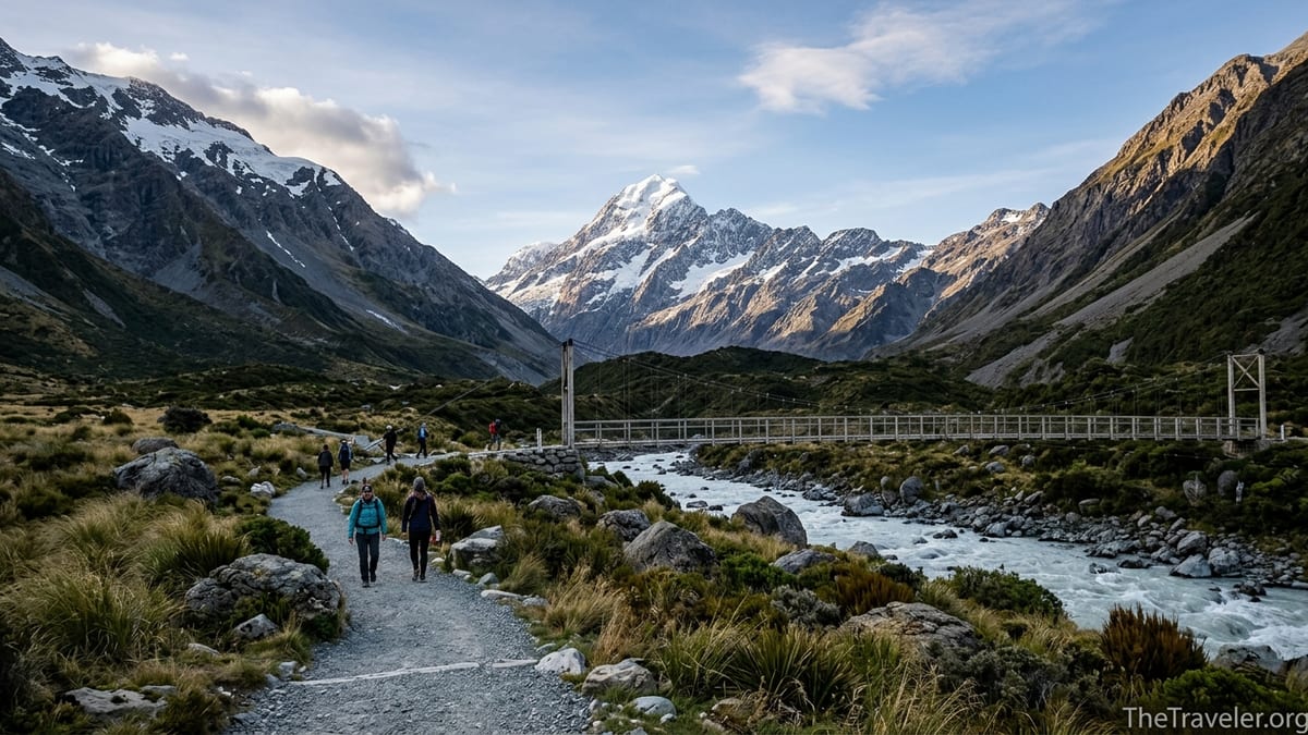
Aoraki/Mount Cook National Park is perhaps the single best place on the South Island for high reward day hikes. You can sleep in Mount Cook Village or at the White Horse Hill campground, then choose from several trails that head straight into glacier valleys beneath New Zealand’s highest peak. The most famous of these is the Hooker Valley Track, a well-formed path that crosses three swing bridges as it follows the Hooker River to a lake filled with icebergs at the base of the Hooker Glacier.
Even though Hooker Valley is almost flat by alpine standards, you should still plan for three to four hours return to enjoy the 10 kilometers of track at a relaxed pace. The elevation gain is modest, generally quoted around 100 to 200 meters, but the valley is exposed to strong sun, wind and cold air rolling off the glacier. There is no shade and no café along the way, so most hikers pack a simple picnic, at least one to two liters of water, sun protection and an extra warm layer for the lakeside viewpoint, where wind chill can be striking even in January.
As of 2026, Hooker Valley has seen periodic partial closures while a damaged swing bridge is replaced. Travelers arriving in early winter have reported being turned around at the first bridge, with access only to the Mueller Lake lookout from the car park. That makes it essential to check the current DOC advisory the day before you commit to the long drive into Mount Cook Village. If the full track is closed, good alternatives include the Kea Point Track, a short, mostly gentle walk to a viewpoint over the Mueller Glacier lake, and the steep but spectacular Sealy Tarns Track, which climbs hundreds of wooden steps to a series of alpine tarns reflecting Aoraki on a calm day.
For hikers looking to push beyond simple valley walks, the Mueller Hut Route starts from the same area and leads to an alpine hut that is often done as a demanding day hike or an overnight trip. The route involves significant elevation gain, rougher terrain and sometimes snow patches even in late summer, and it requires more experience than Hooker Valley or Kea Point. While not a Great Walk, it gives a taste of South Island mountaineering country without committing to multiple days in the backcountry. If you only have a single day in Aoraki/Mount Cook, combining a sunrise stroll to Tasman Glacier Lake with a mid-morning hike up Hooker Valley will give you a strong sense of the park’s glacial landscapes.
Wānaka Region: Roy’s Peak and Rob Roy Glacier
The Wānaka region offers a mix of lakeside ambles and serious climbs, anchored by two standout day hikes: Roy’s Peak and Rob Roy Glacier. The Roy’s Peak Track begins just outside town on Mount Aspiring Road, at a dedicated car park that often fills early during the busy summer months. From the moment you step onto the 4WD farm track you are climbing, and it barely lets up until you reach the ridgeline and, for many people, the classic photo spot overlooking Lake Wānaka and the jagged skyline of Mount Aspiring National Park.
DOC and regional tourism sources list Roy’s Peak as an 11 kilometer return track that typically takes five to six hours to complete, with a climb of around 1,300 meters to the 1,578 meter summit. There is almost no shade, no drinking water on the track and exposure to both intense summer heat and cold winds higher up. In summer it is common to see hikers starting at 5 or 6 in the morning to avoid the hottest part of the day and the parking crush. The track crosses private farmland and closes every year for lambing, usually from 1 October to 10 November, so spring visitors need a backup hike planned.
Rob Roy Glacier Track offers a different kind of challenge. Located in the Matukituki Valley, it starts with a swing bridge over the Matukituki River before climbing through beech forest to a series of viewpoints beneath hanging glaciers and occasional waterfall curtains. The track is shorter than Roy’s Peak, with a more moderate elevation gain that many moderately fit walkers can manage, but it has seen temporary closures over recent years due to slips and damage from heavy rain. The access road is long, partly unsealed and can involve fording small streams, which may void some rental car contracts when water levels are high, so it is wise to check both road and track status locally before you set out.
For travelers who want big views without a full day’s climb, several lower-effort walks around Wānaka deliver strong scenery. The Mount Iron Track is a popular half-day loop close to town with panoramic views, while lakeside walks such as the Outlet Track combine easy gradients with café stops and swimming spots. These easier options are useful rest-day choices between bigger undertakings like Roy’s Peak or Rob Roy Glacier, or for family groups where not everyone is ready for 1,000 meters of ascent.
Queenstown: Ben Lomond and Local Classics
Queenstown calls itself the adventure capital of New Zealand, and its main local summit, Ben Lomond, lives up to that reputation. Rising above the town to a height of 1,748 meters, Ben Lomond is a full-day outing that rewards persistent climbing with far-reaching views over Lake Wakatipu, the Remarkables range and the surrounding peaks. Hiking directly from town involves more than 1,400 meters of elevation gain and can take eight to ten hours return for many visitors, making it a serious undertaking that should not be underestimated.
Many hikers reduce the total climb and time on foot by using the Skyline Gondola, which carries you from central Queenstown to a hilltop complex partway up the route. From the gondola top station, you follow a well-marked trail through tussock and along a ridge to the Ben Lomond Saddle and, conditions permitting, onwards to the summit. Even with the gondola assist you should expect a solid, sometimes steep climb, significant exposure to wind and strong sun, and, in winter and early spring, potentially icy or snowy sections where microspikes and experience on snow may be necessary.
Ben Lomond is not the only worthwhile hike in the Queenstown area. Shorter options like the Queenstown Hill Time Walk provide an intermediate challenge with excellent lake views in two to three hours, while lakeshore tracks such as the Frankton Arm Walkway suit days when weather higher up the mountain looks unstable. Some visitors also use Queenstown as a base for day trips to walks at Glenorchy, such as the start of the Routeburn Track, or to Moke Lake, where an undulating track loops around a high-country tarn with reflections of surrounding peaks.
Logistically, Queenstown is one of the easiest places to arrange transport to and from trailheads. Commercial shuttles run to popular tracks like Ben Lomond and the Routeburn road ends in peak season, and taxis or rideshares can be affordable when shared between a small group. That said, car parks at popular starting points still fill rapidly on clear summer days, so early starts remain the best strategy both to avoid crowds and to maximize your margin for weather changes.
Fiordland: Key Summit and Te Anau Day Hikes
Fiordland National Park, centered on Te Anau and Milford Sound, is renowned for multi-day Great Walks like the Milford and Routeburn Tracks, but it also offers day hikes that sample this wild, wet corner of the South Island without requiring hut reservations. The Key Summit Track is perhaps the best known. Starting from The Divide on the Milford Road, it follows the first section of the Routeburn Track before branching to climb steadily through beech forest and out onto an open, tarn-studded summit plateau with sweeping views on a clear day.
Key Summit is usually described as a three-hour return walk, with moderate elevation gain on a well-formed trail. In fine weather you can see across to the Darran Mountains and back toward the Humboldt Range, but in typical Fiordland conditions clouds and rain may close in quickly, reducing visibility and turning boardwalks and roots slippery. Waterproof jackets, pack covers and a dry bag for important items are everyday essentials here, even if the forecast seems promising when you depart Te Anau in the morning.
Closer to Te Anau, shorter walks such as the Lake2Lake multi-use trail and the Control Gates to Dock Bay track provide low-effort options on days with uncertain weather or when you only have an afternoon free. Along the Milford Road, other DOC waypoints highlight short nature walks to waterfalls, viewpoints and moss-draped forest that are ideal if low cloud or heavy rain make longer adventures unappealing. These stops can be strung together to create a flexible day if conditions at Key Summit or the higher Routeburn Track sections do not cooperate.
Because Fiordland is subject to frequent heavy rainfall, slips and occasional road closures, planning here must remain flexible. It is sensible to stay at least two nights in Te Anau so that you have a buffer day if your Key Summit attempt is washed out by strong wind or poor visibility. Booking Milford Sound cruises or guided walks with changeable dates can also give you options if the weather forces you to reshuffle your hiking plans at short notice.
Nelson, Tasman and the Northern Ranges
The northern tip of the South Island, stretching from Nelson across Tasman Bay to Abel Tasman National Park and inland to Kahurangi and Nelson Lakes, combines coastal tracks with forest and alpine routes. While the Abel Tasman Coast Track is itself a Great Walk, many visitors experience it through day hikes out-and-back from road ends such as Marahau or Wainui, or by using water taxis to link sections rather than committing to the full multi-day trip and hut or campsite bookings.
For instance, a common day outing involves catching an early water taxi from Marahau to a mid-coast beach, then walking five to eight kilometers back along the coastal path to another pickup point or all the way to the road end. These partial sections still involve hills and some exposed stretches of beach that may be affected by tides, but they are generally much less strenuous than alpine summits like Ben Lomond or Roy’s Peak. Sun exposure is a factor here, as much of the track is open and summer temperatures on the sand can feel intense by mid-afternoon.
Inland, Nelson Lakes National Park offers day hikes from St Arnaud such as the Mount Robert Circuit and Lake Rotoiti lakeside tracks, which blend forest with panoramic viewpoints over the water. Kahurangi National Park provides a more rugged experience with options like the first section of the Heaphy Track or short walks near Takaka Hill and the Cobb Valley. Many of these routes sit at higher elevation than the coast, making them cooler in summer but more prone to cold winds and occasional snowfall in shoulder seasons.
Access logistics in the Nelson and Tasman regions vary. The coastal Abel Tasman sections rely heavily on commercial water taxis and sea shuttle operators whose schedules change seasonally and are weather dependent, while inland tracks are generally reachable by standard rental car on sealed or well-maintained gravel roads. Booking your transport a few days in advance in peak season is wise, especially if you are coordinating multiple people, kayaks or luggage transfers around your walk.
The West Coast: Short Walks Between Glaciers and Rainforest
The South Island’s West Coast, stretching from Haast north to Westport, is more about short, scenic walks than full-day alpine climbs, although longer tramps exist inland. The region’s famous glacier valleys at Franz Josef and Fox offer short tracks to viewpoints over the glacier faces, as well as guided glacier hikes and heli-hiking experiences that are only possible with professional operators. These low-effort walks can take as little as 20 to 90 minutes but still carry hazards in the form of heavy rainfall, rockfall zones and changing river courses, which is why access beyond certain points is often restricted to guided parties.
Around Punakaiki, the Pancake Rocks and Truman Track provide easy coastal strolls with dramatic limestone formations, blowholes and wild beaches. Farther south, forest walks such as those near Lake Matheson lead to classic mirror-lake reflections of Aoraki/Mount Cook and the Southern Alps on calm mornings. Elevation gains on these routes are usually minimal, making them suitable for families, but the ground can be slick after rainfall and sandflies can be extremely persistent whenever you stop moving.
The West Coast’s weather can be volatile, with long periods of rain followed by incredibly clear days. Because many trails here are short, they are perfect as flexible stops on a road trip between more demanding hiking destinations like Wānaka and Nelson. A typical itinerary might see you tackling Roy’s Peak one day, then two or three short walks around Franz Josef the next, interspersed with café stops in small towns like Hokitika or Kumara as you head north.
Services along the West Coast are more spread out than around Queenstown or Nelson, so fuel up when you can and check visitor center noticeboards for any track closures or safety warnings. In some areas, such as the glacier valleys, parking lots may be subject to flooding or access changes after major storms, reinforcing the need to keep plans flexible and always have an alternative walk in mind.
Great Walks vs Day Hikes: How to Divide Your Time
Many travelers arrive on the South Island having heard names like Milford Track, Routeburn Track and Kepler Track, all of which are Great Walks with hut systems, quotas and booking seasons. These multi-day routes are extraordinary, but they require planning months in advance and do not always fit into itineraries that only allow a few days in each region. For most visitors, a smart approach is to treat Great Walks as optional centerpieces and build the rest of the trip around more flexible day hikes.
Several of the day walks in this guide use sections of Great Walks as out-and-back routes. Key Summit, for example, follows the Routeburn Track from The Divide before branching upward, giving you a taste of the scenery without needing to book huts. Parts of the Kepler Track near Te Anau can be enjoyed as day hikes, such as the Control Gates to Luxmore Hut section for strong walkers craving a long day out. Along the Abel Tasman Coast Track, water taxis allow you to pick small sections to walk in a single day, combining the Great Walk environment with hotel comforts in nearby towns.
In practice, a two-week South Island itinerary might include a single two or three-night Great Walk, combined with day hikes in Aoraki/Mount Cook, Wānaka, Queenstown, Fiordland and Abel Tasman. A traveler flying into Queenstown could spend a day on Ben Lomond, drive to Te Anau for Key Summit and a short Kepler section, then continue to Mount Cook Village for Hooker Valley or Sealy Tarns before finishing with a coastal walk in Abel Tasman. This mix balances hut life and backcountry immersion with the flexibility and comfort of returning to a lodge or motel most nights.
If you are set on a particular Great Walk, such as the Milford Track, it is crucial to consult the latest DOC booking calendar and plan your day-hike schedule around those locked-in dates. Shifting a day walk like Roy’s Peak is usually easy. Shifting a multi-day hut reservation often is not. Using day hikes as the flexible backbone of your trip lets you respond to weather, energy levels and local advice without feeling that you have missed the essence of South Island tramping.
The Takeaway
The South Island rewards hikers who are honest with themselves about fitness, curious enough to look beyond the “top ten” lists, and flexible in the face of changeable weather. Tracks like Hooker Valley, Roy’s Peak, Ben Lomond, Key Summit and Rob Roy Glacier have earned their reputations for good reason, but they are only the beginning of what the island has to offer. Nearby alternatives such as Kea Point, Sealy Tarns, Queenstown Hill and partial sections of the Abel Tasman and Kepler Tracks can deliver equally memorable days with different levels of effort.
When choosing between them, compare not just the distance and elevation figures, but also exposure, access logistics and seasonal quirks like lambing closures or bridge repairs. Add in realistic driving times, crowded summer car parks and the reality that you may want an easier day after a big climb. In Aoraki/Mount Cook you might pair Hooker Valley with a short Tasman Glacier viewpoint; in Wānaka you might tackle Roy’s Peak early one morning and then stroll the lakeshore the next evening.
Above all, remember that the goal is not to tick off as many famous trail names as possible, but to experience the South Island’s variety of landscapes at a pace that feels sustainable and enjoyable. Whether you are standing beneath the hanging glaciers of Rob Roy, watching clouds shred around Aoraki from the Hooker Lake shore, or catching your breath on the final zigzags to Ben Lomond’s summit, choosing the right hike for the day will make every step feel worthwhile.
FAQ
Q1. Do I need to book in advance for day hikes like Hooker Valley or Roy’s Peak?
For most South Island day hikes, including Hooker Valley, Roy’s Peak, Ben Lomond and Key Summit, you do not need to book the track itself or pay an entry fee. However, you may need to pre-book transport such as the Queenstown gondola for Ben Lomond access or water taxis for Abel Tasman day walks, especially in peak summer. Always check for seasonal closures, such as the annual lambing shutdown on Roy’s Peak, before you travel.
Q2. How fit do I need to be to hike Roy’s Peak compared with Hooker Valley?
Hooker Valley is suitable for most reasonably active visitors because it is about 10 kilometers return on a gently graded, mostly flat track with modest elevation gain. Roy’s Peak, by contrast, involves roughly 1,250 to 1,300 meters of continuous climbing over around 11 kilometers return, with little shade and no water on the track. If you are comfortable climbing stairs or hills for several hours and have proper footwear, Roy’s Peak is achievable, but it is significantly more demanding than Hooker Valley.
Q3. What is the best season to hike on the South Island?
The main hiking season runs roughly from late October to April, when days are longer and snow is mostly limited to higher peaks. Summer brings the warmest temperatures but also the biggest crowds and busiest car parks. Shoulder seasons like November and March often offer a good balance of stable weather and fewer people, though alpine routes such as Ben Lomond or higher sections of the Routeburn can still see snow or ice. Winter hiking is possible on lower tracks such as Hooker Valley or lakeside walks, but you must be prepared for cold, short days and potential closures.
Q4. Are guided hikes worth considering, or can I walk independently?
Many South Island day hikes, including Hooker Valley, Roy’s Peak, Rob Roy Glacier and Key Summit, are commonly done independently by visitors with basic outdoor experience, good preparation and suitable gear. Guided walks can be valuable if you are nervous about navigation, want local insight into geology or wildlife, or plan to go onto glaciers or more technical alpine routes where professional equipment and expertise are essential. In places like Franz Josef and Fox glaciers, walking on the ice is typically only possible with a licensed guide.
Q5. How should I plan transport and parking for popular hikes?
For high-demand tracks such as Roy’s Peak and some Queenstown routes, car parks can be full by mid-morning in peak season. Starting early is the simplest solution. In hubs like Queenstown, Te Anau and Wānaka, shuttle services and taxis provide alternatives that let you avoid parking issues and one-way road sections. When hiking coastal routes like Abel Tasman, water taxis often dictate your start and end points, so you should book those first and plan your walking distances around the scheduled pick-up and drop-off times.
Q6. What basic gear do I need for South Island day hikes?
At a minimum you should have sturdy footwear with good grip, weatherproof layers including a waterproof jacket, sun protection, enough water for the day and high-energy snacks. A small daypack, a hat, gloves in shoulder seasons and a basic first-aid kit are strongly recommended. For steeper or longer hikes such as Ben Lomond, Roy’s Peak or Sealy Tarns, trekking poles can reduce strain on knees and help with balance on descents. In winter or early spring, some alpine routes may require additional gear like microspikes, which should only be used if you understand how to travel safely on snow and ice.
Q7. Can I rely on mobile reception and digital maps on the trails?
Coverage varies widely. Around Queenstown, Wānaka and some parts of Aoraki/Mount Cook you may have intermittent reception, while in Fiordland, the West Coast and remote valleys you should assume there will be little or none. It is wise to download offline maps for apps you use, carry a paper map for longer or more complex routes, and let someone know your plan and expected return time. Do not rely on being able to call for help from the track itself.
Q8. Are there any specific hazards I should know about besides weather?
Common hazards include strong sun exposure, especially on open tracks like Roy’s Peak and Ben Lomond; slippery rocks and roots after rain; and rapidly rising rivers on routes that involve stream crossings. In some areas, such as glacier valleys on the West Coast, rockfall zones and unstable riverbeds mean you must obey signs about no-go areas beyond certain points. Sandflies can be a significant nuisance in West Coast and Fiordland valleys, so many hikers carry insect repellent and light, long-sleeved clothing to reduce bites.
Q9. How do day hikes fit into an itinerary that also includes a Great Walk?
Day hikes work well as flexible components before or after a fixed multi-day Great Walk. For example, you might book three nights on the Routeburn Track, then plan day hikes at Aoraki/Mount Cook, Queenstown or Abel Tasman around those dates. Because day walks do not require hut bookings, you can move them earlier or later in your schedule in response to weather, fatigue or local advice, while keeping your Great Walk as the anchor experience.
Q10. Is it safe to hike alone on popular South Island tracks?
Many people hike solo on well-trafficked routes such as Hooker Valley, Roy’s Peak, Ben Lomond and Key Summit, and the presence of other walkers can add a sense of security. However, solo hiking still carries risk. If you choose to go alone, select routes that match your experience, start early, check the forecast and current track conditions, and tell someone where you are going and when you expect to be back. Carrying a personal locator beacon or similar emergency device is a sensible precaution, particularly on quieter trails or outside peak season.