

On a blue-sky July morning in Tongariro National Park, I thought I had done everything right. The forecast promised clearing showers, light winds and a high of 2 degrees Celsius on the plateau. I had tramped in New Zealand before, including parts of the Tongariro Northern Circuit in late summer. So when I booked a winter road trip through Tongariro, Arthur’s Pass and Aoraki/Mount Cook National Parks, I expected colder versions of familiar hikes. What I underestimated, again and again, was how completely snow and ice, track closures and short days would transform “ordinary” summer walks into something closer to mountaineering.
Winter in New Zealand’s National Parks Is Not Just “Colder Summer”
New Zealand’s national parks sit in a narrow, mountainous country where weather systems roll in quickly from the Tasman Sea and Southern Ocean. In July and August, the combination of maritime storms, steep terrain and limited daylight changes the entire character of popular hikes. The New Zealand Mountain Safety Council (MSC) notes that winter tramping requires extra caution, thorough preparation and a realistic match between your skills and the conditions. Their message is blunt: alpine routes that feel like demanding day walks in February become technical, potentially hazardous undertakings once snow and ice settle on the ridgelines.
My own itinerary looked modest on paper. Starting in Turangi, I planned a circuit through Tongariro National Park, then down the South Island to Arthur’s Pass National Park and finally to Aoraki/Mount Cook National Park. The backbone of the trip was a series of classic “day hikes” many visitors treat as bucket-list items: the Tongariro Alpine Crossing, the Bealey Spur Track in Arthur’s Pass, and the Hooker Valley Track beneath Aoraki. I knew I would need warmer gear, but I still filed them mentally alongside summer experiences I had already had. That mindset, more than the snow itself, turned out to be my biggest mistake.
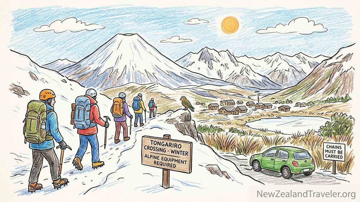
Even at lower elevations, winter closes roads, freezes water sources and hides track markers. On State Highway 1 approaching National Park Village, roadside signs flashed warnings about black ice long after the sky had cleared. At Arthur’s Pass, large electronic boards on State Highway 73 alternated between “Chains must be carried” and “Chains must be fitted” depending on the latest squall over Porters and Arthur’s Passes. In Aoraki/Mount Cook Village, the road to the Hooker Valley car park was closed for several mornings after overnight snowfalls, forcing walkers to add an extra hour on foot just to reach the trailhead.
None of these realities are secrets. The Department of Conservation (DOC) and MSC publish prominent winter alerts, avalanche advisories and track notices each year. The problem is that it is easy for visitors, especially those with solid summer tramping experience, to skim past those warnings and treat winter as a gear issue instead of a genuine change in terrain seriousness.
A Real Winter Day on Tongariro: From Confident Plans to Turning Back
The clearest illustration of this gap between expectation and reality came on my attempt at the Tongariro Alpine Crossing in mid-July. The evening before, the MetService mountain forecast showed early snow showers easing to fine, with winds dropping below 30 kilometers per hour on the tops and a freezing level around 1100 meters. The forecast maximum at Red Crater, the high point of the crossing at 1868 meters, was roughly minus 4 degrees Celsius, not counting wind chill. DOC’s Tongariro winter information stressed that the route in winter crosses avalanche terrain, and that additional hazards include hard ice, deep snow drifts and sub-zero temperatures.
I booked a guided trip rather than attempting a “freedom” hike. That decision alone probably kept the day safe. In winter, DOC and local shuttle operators are explicit that the crossing is an alpine route requiring crampons, an ice axe and avalanche awareness; most independent shuttle companies stop operating in full winter, while specialist guiding companies continue with small groups, qualified guides and safety equipment included. When our group of eight met the guide in National Park Village at 6 am, the temperature was minus 5 degrees at road level and the dawn sky was clear. It felt, in other words, like a promising day.
By the time we reached the Mangatepōpō Road end, the differences from summer were obvious. The car park that had been a dusty, crowded scene in February was half-covered in old wind-packed snow, and the access road had “snow chains essential” signs still folded away at the roadside from earlier in the week. The guide checked each person’s gear: insulated boots, gaiters, waterproof jacket and pants, thermal layers, hat and gloves, plus a second spare layer and extra gloves in the pack. Crampons and ice axes stayed in the guide’s pack for the lower valley, but every person also carried a helmet, avalanche transceiver, shovel and probe. This was no longer a scenic walk between volcanic craters; it was treated like a full alpine journey.
We moved quickly up the Mangatepōpō valley in still, cold air. In summer this section is an easy warm-up on constructed boardwalks. In winter, those same boardwalks were rimed with refrozen meltwater, the gaps between slats now potential ankle traps hidden by a dusting of new snow. At Soda Springs, the last toilet stop, we pulled on harnesses and adjusted crampons. The famous Devils Staircase looked completely different: a steep ramp of hard snow, the summer steps buried. The guide cut a fresh line off to one side to avoid bulletproof ice and explained that overnight katabatic winds had polished the surface in places. Two parties who had started ahead of us without guides stopped here, looking up at the slope with trekking poles that now seemed laughably inadequate.
Ice, Avalanche Terrain and the Moment We Turned Around
The climb to the South Crater saddle was a lesson in how winter alters risk. In summer, the track is a well-defined line of steps and gravel switchbacks. On this July morning, it was a broad, white slope where the only sign of traffic was a faint series of old boot marks and the occasional orange DOC marker post poking out of the snow. The guide led in a zig-zag to manage the angle, demonstrating how to kick steps and use the ice axe in “piolet canne” position. Wind picked up as we crested the saddle and spilled into the wide bowl of South Crater, gusts tearing loose plumes of snow from the ridges above.
The real crux, as anyone who has studied the winter brochure for the crossing will know, is the ascent to Red Crater. The upper section is narrow, exposed and lies within mapped avalanche terrain. The New Zealand Avalanche Advisory had issued a moderate danger rating for the day, with specific concern about wind slabs on lee slopes after a recent storm. We roped up in short pitches, partly for practice and partly because the guide wanted tight control on that narrow ridge. This was the point where my mental image, shaped by glamorous social media shots of people strolling along a frosty path, fell apart.
Halfway up to Red Crater, visibility dropped abruptly as a cloud bank rolled over. In less than ten minutes, blue sky became an indistinct grey wall. The track edge and the steep drop toward the Central Crater vanished in flat light. Wind gusts began to knock us sideways, making it difficult to keep crampon points seated in the hard snow. The guide checked the time, the weather update on a satellite device and our group’s pace, then called it. We would not go to Red Crater or down the steep, avalanche-prone slope toward the Emerald Lakes. Instead, we would retreat to South Crater and return the way we had come.
On paper, that might sound like a disappointing half-day. In practice, the descent required just as much concentration. Places that had felt manageable on the way up now involved facing into the slope, chopping fresh steps and using the axe in self-belay position. The wind was funneling down the valley, scouring snow off ridges and sending it stinging into our faces. Temperatures remained several degrees below freezing, and even with high-quality waterproofs and winter gloves my hands began to numb whenever we paused. By the time we reached the valley floor again, I understood very clearly why DOC and MSC emphasize that in winter the Tongariro Alpine Crossing is not an advanced day hike but a technical alpine route.
Road Closures, Snow Chains and the Invisible Part of Winter Tramping
One of the easiest mistakes for overseas visitors is to focus only on the track and forget the road. Throughout this trip, getting to the trailhead safely was often the most complex piece of logistics. In the central North Island, the access roads to Mangatepōpō and Ketetahi trailheads turn from benign gravel driveways in summer into icy, shaded lanes where rental cars without snow chains struggle. After a cold front, local councils may close these side roads while graders and grit trucks operate, even if the main highway is open.
Further south, Arthur’s Pass added an extra layer of reality. State Highway 73, which crosses both Porters Pass and Arthur’s Pass, is one of the country’s main alpine highways. In winter, the transport authority regularly imposes chain-carry requirements or full chain-fitting restrictions for two-wheel-drive vehicles. On my July passage, we woke in Arthur’s Pass Village to minus 7 degrees and a notification that the highway was temporarily closed in both directions due to fresh snow and multiple vehicles sliding near Otira Viaduct. The Bealey Spur trailhead, an easy 15-minute drive in benign conditions, might as well have been on the moon until the road crews had finished.
At Aoraki/Mount Cook, road issues took a different form. The 55-kilometer access road from State Highway 8 to the village is generally well-maintained, but overnight snowfalls meant black ice on shaded corners well into the afternoon. On one morning, the side road from the village to White Horse Hill campground, where the Hooker Valley Track begins, was closed to all vehicles while staff assessed avalanche exposure from nearby slopes and cleared debris. Walkers were free to proceed on foot but had to add roughly four kilometers return to their day. That might not sound serious on a crisp, sunny morning. Add gusty wind, scattered snow showers and a 4 pm sunset, and you start to understand why MSC encourages people to factor access time and daylight carefully into any winter plan.
Snow chains themselves come with a learning curve. Many New Zealand rental companies allow winter driving in alpine areas but expect customers to fit chains when required. Standing in a slushy car park at dawn in Arthur’s Pass, trying to wrestle frozen metal links onto cold tires, is a humbling experience if you have only ever seen chains in photos. Practicing beforehand in dry conditions and traveling with waterproof gloves dedicated to chain fitting are the kind of practical details that rarely appear in Instagram captions but make a huge difference to how stressful a winter day feels.
Why “Summer Grade” Means Very Little in July
Perhaps the most persistent misconception I encountered talking with other travelers was the belief that a track graded as an “easy” or “intermediate” tramping route in summer retains that character year-round. Both DOC’s grading system and popular guidebooks typically describe tracks in their most common summer condition. In winter, snow and ice can obscure markers, cover boardwalks and bridges, and completely change the seriousness of river crossings and sidle sections. Even short family walks take on different risk profiles once surfaces freeze and daylight shrinks to nine or ten hours.
The Tongariro Alpine Crossing is the most obvious example. In summer, tens of thousands of people complete it with solid footwear, layered clothing and good fitness. By late May, however, shuttle operators begin to scale back. Several companies explicitly stop “freedom hiking” shuttles once significant snow and ice appear, usually in late May or June, because they consider the route unsafe for people without winter alpine skills and equipment. Instead, guided operations continue with crampons, ice axes and avalanche rescue tools as standard issue, alongside qualified guides who make go or no-go decisions on the day.
The pattern repeats elsewhere. The Routeburn and Kepler Tracks, marketed as Great Walks and extremely popular from November to April, revert to “winter tramping routes” after the main season. DOC warns that from late autumn to spring, these tracks can involve avalanche terrain, unbridged streams, deep snow and ice-covered boardwalks. Hut services are reduced, bridges may be removed in flood-prone areas, and only trampers with advanced skills and appropriate gear are advised to attempt the full routes. A summer three-day hut-to-hut excursion with maintained facilities becomes, in winter, a largely self-reliant alpine journey.
Even comparatively low Great Walks refocus in winter. On the Heaphy Track in Kahurangi National Park, for example, the winter season from May to September allows mountain biking but also coincides with cooler, wetter weather and the risk of river flooding on the West Coast side. While the track is not alpine in the same way as Tongariro or Fiordland’s high passes, winter still adds layers of complexity that are not obvious from summer brochures.
Alpine Hazards, Avalanche Awareness and the Gear Gap
The MSC emphasizes that winter tramping in alpine areas demands specific skills and equipment. Their advice is consistent wherever you look: carry warm layers, waterproof outerwear, gloves and hats, extra food and water, and emergency gear such as a personal locator beacon. In alpine zones, add crampons, an ice axe and an avalanche rescue kit. Crucially, none of this equipment is useful without the skills to apply it under pressure.
Throughout my trip, I was struck by the “gear gap” between what visitors wore and what local guides considered standard. On the July Tongariro trip, several independent walkers at the car park had lightweight trail-running shoes, thin leggings and a single waterproof jacket that might be adequate for a cool autumn day. Some had printed screenshots of a forecast but no understanding of how a moderate avalanche rating should influence route choice. In contrast, our guide treated the avalanche advisory, freezing level, wind speed and recent snow history as non-negotiable inputs. When visibility dropped and wind rose, the call to turn back was immediate, not something to debate while pushing “just ten more minutes.”
In Arthur’s Pass, the difference was subtler. Bealey Spur, a popular day walk that climbs gradually from farmland into subalpine tussock with views into the Waimakariri River, often sits just at the snowline in winter. On my visit, a dusting of fresh snow covered tree roots and rocks, turning otherwise trivial steps into slippery puzzles. Higher up, short sidle sections crossed steep, snow-covered slopes where a slip would have had real consequences. I met two trampers returning early who had microspikes and trekking poles but chose to retreat at the first exposed section because they did not feel confident in their self-arrest skills if something went wrong. Their decision to back off, rather than treat the track grade as a promise, was exactly the attitude MSC tries to cultivate.
Avalanche risk extends beyond obvious ski terrain. DOC winter information for the Routeburn Track, for instance, highlights multiple avalanche paths that cross the track, particularly near Harris Saddle. Similarly, Mount Aspiring National Park’s Rees-Dart Track includes slopes prone to avalanches and serious rockfall. These routes may be entirely safe in stable, low-danger conditions but demand constant reassessment as weather patterns shift. The availability of regional avalanche forecasts is a powerful tool, but only if trampers take the time to read and understand them.
The Instagram Problem: Beautiful Photos That Hide Risk
Part of what feeds complacency about winter tramping in New Zealand is the way these landscapes appear online. Social media overflows with images of people standing beside the frozen Emerald Lakes, walking across snowy swing bridges or posing against backgrounds of snow-draped beech forest. What those images rarely convey is wind speed, surface hardness, avalanche overhead, or the hours of decision-making that went into choosing that particular day and that particular turnaround time.
On Tongariro, for example, the photos that persuaded me to plan a winter attempt all showed calm, crystalline days with perfect visibility. Guides I spoke with, however, estimated that in a typical winter they cancel or modify a significant proportion of planned trips due to high winds, whiteouts or unstable snowpack. Many of the “classic” images were captured on a handful of rare bluebird days that happened to coincide with safe avalanche conditions and low wind. Treating those photos as a baseline expectation is like assuming every city looks and feels like it does on postcard-perfect evenings.
Even apparently benign scenes can hide risk. A mid-winter image of the Hooker Valley Track, with fresh snow smoothing the boardwalk and mountains sparkling in the sun, looks enticing. What you do not see are the patches of black ice on shaded steps, or the sections where avalanches from Mount Sefton’s flanks occasionally reach the valley floor and temporarily close the track. Close-up shots of hikers in Arthur’s Pass smiling under light flurries do not reveal the icy corners on the highway that led them there, or the snow-choked drain that closed the road entirely two days before.
There is also the problem of survivorship bias. People rarely post detailed accounts of turning back at the South Crater of Tongariro due to high wind or abandoning a Bealey Spur ascent after losing the track in cloud. Yet those are exactly the stories that capture the real discipline of winter tramping: choosing caution, accepting sunk costs and treating the mountains as they are instead of how we wish them to be for the sake of an image.
Winter Experiences Worth Seeking Out
For all this focus on hazard, winter in New Zealand’s national parks can be profoundly rewarding. Some experiences became highlights of my trip precisely because I treated them as winter-specific adventures rather than off-season versions of summer walks. Chief among these were guided alpine trips that embraced the full winter environment with the right skills and safeguards.
Returning to Tongariro, I would absolutely recommend a guided winter outing for visitors who are fit, comfortable walking 6 to 8 hours and eager to learn basic use of crampons and an ice axe. Even when we turned back before Red Crater, crossing the frozen South Crater under shifting cloud was unforgettable. The guide’s running commentary on snowpack, safe spacing on slopes and decision-making under changing conditions offered insights I could never have gained from a dry trail in March. Importantly, that value remained even without reaching the iconic Emerald Lakes viewpoints.
In Aoraki/Mount Cook, the Hooker Valley Track on a clear winter afternoon was another standout. After several mornings of road closures and cloud, a high-pressure window delivered calm air and strong, low-angle light that made ice on the Hooker Glacier shimmer. The low sun, common in winter, turned an already photogenic valley into something almost theatrical. Temperatures hovered just above freezing, yet because the track is relatively low, well-graded and closely monitored, the main challenges were patches of ice on boardwalks and managing the short daylight. With microspikes, trekking poles, proper layers and a strict turnaround time tied to sunset, the walk felt demanding but not extreme.
Lower-elevation forest and coastal tracks emerged as the real winter sweet spot. Routes like parts of the Heaphy Track in Kahurangi National Park, sections of the Abel Tasman Coast Track, or short walks in Paparoa and Egmont National Parks keep you largely below the deep snowline. In these environments, winter often brings clearer air, fewer sandflies and a quieter, more contemplative experience. While storms and river flooding remain hazards, you can avoid the particular mix of avalanche exposure, whiteouts and technical ice that define the high alpine parks.
The Takeaway
Looking back on my winter loop through Tongariro, Arthur’s Pass and Aoraki/Mount Cook, the main lesson is not that New Zealand’s national parks are too dangerous in July. It is that they are genuinely different places than they are in summer and demand a different mindset. Treating a “summer grade” as a year-round promise, or assuming that a popular Instagram shot reflects everyday conditions, is an easy path to trouble.
The experiences I would recommend without hesitation are winter trips that match their conditions: guided alpine days in Tongariro for those who want to taste crampons and ice axes under expert supervision; well-timed walks like the Hooker Valley Track or similar low-alpine routes when road access is safe and avalanche hazard is low; and a wide range of forest and coastal tracks where snow is minimal and winter’s crisp light and empty paths become an advantage.
Trips I would reserve for those with specialist skills or the support of a qualified guide include any high alpine crossing that enters mapped avalanche terrain, such as Tongariro in full winter condition or multi-day Great Walks that cross major passes like the Routeburn or Kepler. For these, you need not just the right equipment but also the judgment to interpret forecasts, read the snowpack and turn around early without regret.
Perhaps the smartest winter strategy of all is to pivot your expectations. Instead of chasing summer itineraries in colder clothes, build a winter-specific plan around lower-elevation forests, coastal headlands and selectively chosen alpine experiences with solid backup options. If you carry the warm layers, waterproofs, gloves, extra food and emergency gear that MSC urges, check road, weather and avalanche updates diligently, and remain willing to turn back, New Zealand’s national parks in winter can move from underestimated risk to unforgettable reward.
FAQ
Q1. Can I hike the Tongariro Alpine Crossing in winter without a guide?
In full winter conditions, local authorities and operators strongly advise using a qualified alpine guide unless you have advanced winter skills, crampon and ice axe experience, and avalanche awareness, because the route crosses steep, icy slopes and avalanche terrain.
Q2. Do I really need snow chains to drive to New Zealand national parks in July?
On alpine highways such as State Highway 73 to Arthur’s Pass and access roads in Tongariro and Aoraki/Mount Cook, chain-carry or chain-fit restrictions are often enforced after snow; you may be turned back or risk losing insurance coverage if you ignore these rules.
Q3. How cold does it actually get on popular winter tracks?
On exposed alpine routes like the Tongariro Alpine Crossing or Routeburn high points, winter temperatures commonly sit below freezing, and wind chill can push conditions well below minus 5 degrees Celsius even when nearby towns feel relatively mild.
Q4. Are New Zealand’s Great Walks open in winter?
Most Great Walk tracks remain physically open, but they revert to unserviced “winter tramping routes” with reduced facilities, avalanche exposure, snow and ice, and unbridged streams, and are recommended only for experienced trampers equipped for alpine conditions.
Q5. What extra gear should I carry for winter day hikes in New Zealand?
In addition to your normal tramping kit, you should pack warm insulating layers, a waterproof jacket and pants, hat, gloves plus spares, extra food, a headlamp, and for alpine trips, crampons, an ice axe and avalanche rescue equipment, along with a personal locator beacon where possible.
Q6. How short are winter days, and how does that affect trip planning?
In mid-winter, many South Island locations see around nine to ten hours of daylight, so you need to start early, set strict turnaround times well before dark and factor in slower travel on snow and ice when estimating how long a track will take.
Q7. Are lower-elevation forest and coastal tracks really safer in winter?
They usually avoid deep snow and avalanche terrain and sit closer to roads and shelters, which reduces some risks, though you must still watch for heavy rain, swollen rivers and slippery roots or boardwalks.
Q8. How reliable are winter weather forecasts in New Zealand’s mountains?
Forecasts from official services provide a vital starting point, but conditions in alpine areas can change very quickly, so you should treat forecasts as guidance, check for updates on the morning of your trip and remain prepared to turn back if the weather deteriorates unexpectedly.
Q9. Why do some shuttle companies stop operating in winter?
Many Tongariro and alpine shuttle operators suspend “freedom hiking” services once snow and ice arrive because they consider the track unsafe for unguided walkers who lack winter equipment and skills, and they do not want to encourage people into technical conditions.
Q10. Is hiring a guide worth the cost for winter tramping?
For complex alpine routes, paying for a reputable guide buys local knowledge, safety equipment, real-time decision-making and the ability to learn winter techniques in a controlled environment, which can turn a potentially risky undertaking into a challenging but manageable experience.