

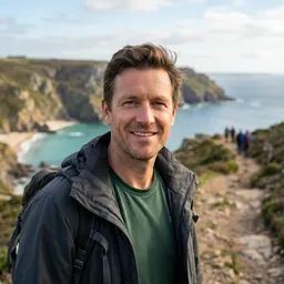
I started the Ben Lomond Track in Queenstown with two numbers stuck in my head: roughly 1,438 metres of climbing and up to eight hours on my feet. On paper it looked manageable. In reality it was one of the toughest and most rewarding day hikes I have done in New Zealand, a steady test that only truly bares its teeth above Ben Lomond Saddle. This is what the route felt like step by step, and what I wish I had known before I set off.
Choosing a Route: From Town or via Skyline
I hiked Ben Lomond on an early autumn weekday, starting from central Queenstown just after 7.30 am. The Department of Conservation (DOC) grades the summit route as an advanced tramping track, with around 1,438 metres of elevation gain from town and a return time of roughly 6 to 8 hours in good conditions. That classification is not a formality. It reflects how sustained the climb is, how rough the upper section becomes, and how quickly the weather can turn in the alpine basin above the treeline.
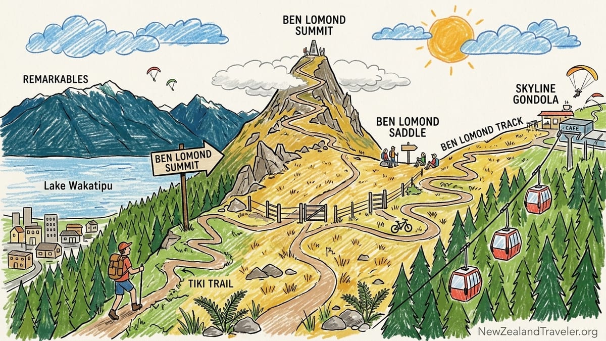
From town I walked up through the steep streets above Queenstown Bay and entered the forest at the base of the Tiki Trail, the most direct way to reach the Skyline gondola top station on Bob’s Peak. Starting here adds about an hour to the day compared with taking the gondola and begins with firm, rooty forest switchbacks. Many hikers, especially those with only one free day, buy a gondola ticket to remove much of this initial climb. In 2026 adult gondola rides from Skyline Queenstown are advertised at around 69 New Zealand dollars for a return trip, so skipping the forest slog is not cheap, but it does preserve energy and time for the alpine section.
I chose to walk the whole way from town partly for the satisfaction of a ground-up ascent and partly to feel the full progression from lakeside to summit. That decision added effort, but it also made the Skyline building a natural first milestone and refuelling point. It is worth being honest about your fitness at this stage. If an hour of continuous uphill through the forest already feels like your limit, the summit will be an uncomfortable stretch even if you ride the gondola.
Reaching the Skyline complex around 8.30 am, I took a short break on the deck looking back over Lake Wakatipu and the Remarkables. This is the last easily accessible water and food on the route. Inside, the café sells takeaway coffee, pastries and bottled drinks, but once you step onto the Ben Lomond Track proper there are no taps, huts or streams that DOC recommends as drinking water. I filled my bottles to a touch under three litres, ate a quick snack, and walked past the luge and paragliding launch area into open tussock country.
Weather, Water and What I Carried
Because Ben Lomond tops out around 1,748 metres, you are dealing with true alpine conditions, even though the track begins almost in the middle of a busy resort town. I picked a March day that started clear and still around 8 degrees Celsius in Queenstown, with a forecast high of about 18 degrees in town and cooler air expected on the ridge. Typical March days in Queenstown hover in the low to mid teens, and wind can make it feel far colder on exposed saddles and summits.
Water planning is critical. Beyond the Skyline complex the track climbs through tussock and scree with no serviced water points. Small creeks sometimes cross the lower section, but they are not reliable and may run dry late in summer or be contaminated by stock higher on the range. DOC and local guides advise carrying all the water you need from town or Skyline. I carried just under three litres, split between a hydration bladder and a bottle, along with a lightweight filter in case I needed to top up from a flow. Even on a mild day I went through most of it by the time I was back at the saddle from the summit.
My pack was the usual New Zealand alpine day-hike blend: a waterproof shell, a light insulated jacket, a beanie, gloves, a spare base layer, headlamp, small first-aid kit and enough food for eight hours on the move. Ben Lomond is not a technical climb in summer, but above the saddle the track is exposed on several sides, and the weather changes quickly. On the day I hiked, clouds built over the summit by late morning, the wind lifted sharply and the temperature dropped by several degrees between the saddle and the final ridge.
Winter conditions are a different proposition altogether. DOC warns that in snow and ice, the upper Ben Lomond Track enters avalanche terrain, and alpine equipment may be necessary. In practice that means crampons or microspikes, an ice axe if you are venturing into steeper slopes and the skills to use them. Local hikers often treat the summit as a mountaineering objective between roughly June and September, especially after fresh snow. If you plan a winter attempt, it is wise to speak directly with staff at the Queenstown DOC Visitor Centre, who can provide up-to-date advice on snowpack, avalanche risk and whether the track is safe beyond the saddle.
Skyline to Ben Lomond Saddle: Where the Work Really Begins
The character of the Ben Lomond Track changes abruptly when you leave the bustle of Skyline behind. Almost immediately you pass through gates that separate the walking route from mountain-bike trails maintained by the Queenstown Mountain Bike Club. Clear signposts mark the tramping track, but you still cross or run parallel to bike trails in a few spots. In dry weather it is easy to distinguish the benched walking line from the bermed bike tracks, but in poor visibility or low light it would be possible to make a wrong turn, so paying attention to DOC’s orange markers is important.
The track climbs steadily along an open spur through manuka and tussock, and for a while the gradient feels deceptively friendly. This is the section where many hikers relax into the walk and start taking photos of the town shrinking below and the Remarkables stretching across the lake. For me, the hike moved from pleasant to genuinely strenuous just beyond the halfway point to the saddle, at roughly 1,200 to 1,300 metres of elevation. The ground underfoot here becomes rockier, with occasional loose gravel and more uneven steps cut into the hill.
It took me a little under two hours of continuous climbing from Skyline to reach Ben Lomond Saddle at around 11 am. Including the Tiki Trail from town, my ascent time to the saddle was slightly over three hours, including short stops for water and photos. This lined up with the common advice that a town-to-saddle walk can take about three to four hours for reasonably fit hikers on a dry summer or autumn day. At the saddle itself, a DOC sign makes an important point: continuing to the summit is significantly more demanding, and DOC recommends that only experienced and well-equipped trampers carry on beyond this point in winter or marginal weather.
The saddle feels like a natural endpoint. You stand on a wide grassy notch looking out to Moke Lake and the Richardson Mountains to the west, while behind you Queenstown and Lake Wakatipu spread out in miniature. Many hikers drop their packs, have lunch, take their photos and turn around here. If you are feeling tired at the saddle, or if clouds are already dragging across the summit ridge, this is the sensible place to finish your day. The temptation to “just see how far up the summit track” you can get can be strong, but the harder work is still ahead.
Ben Lomond Saddle to Summit: The Track Gets Serious
From Ben Lomond Saddle to the summit, the route changes in both gradient and exposure. The sign at the saddle estimates another hour to 90 minutes to reach the top, with a similar time to return. That may sound like a modest extension, but it is packed into a short, steep kilometre and a half of climbing. For me, this was where the tramping-grade classification on DOC’s map came fully to life.
The summit track initially zigzags up the tussock slope, but quickly narrows into a rocky ridge with sharper switchbacks. Underfoot the surface becomes a mix of loose stones and packed dirt, and in places the path cuts across steep scree. In dry conditions and with good boots it is manageable, but it demands concentration, especially when you meet descending hikers who need space on the narrow line. I found my breathing rate jumping noticeably on this section, and my pace slowed to a steady, deliberate plod. The sense of exposure increases too. On my climb a bank of cloud pushed in from the west, wrapping the upper ridge in mist and reducing visibility down to perhaps 30 or 40 metres at times.
Physically, I would mark the point where the trail became significantly harder as the first set of tight, rocky switchbacks above the saddle, within about 15 to 20 minutes of leaving the grassy notch. From there until roughly five minutes below the summit, the gradient is unrelenting. Trekkers used to long European or North American switchbacks may be surprised at how directly the track tackles the fall line here. Trekking poles helped save my knees and added stability on the looser patches, and I was glad I carried them. By the time I pulled onto the summit ridge it had been close to four and a half hours since I left town, with just over four hours of that moving time.
On a clear day, photos show Ben Lomond’s summit delivering a 360-degree panorama that stretches over the Remarkables, the Humboldt Range, the jagged profile of Cecil and Walter Peak across the lake, and deep into the interior towards Mount Aspiring National Park. In my case, the weather offered a lesson in alpine humility. The cloud that had been flirting with the ridge finally thickened as I reached the top. For several minutes I could see little more than shifting grey around the trig and the occasional silver flash of Lake Wakatipu through thin gaps. Then, just as quickly, the sky opened for short windows, revealing the lake and ranges in dramatic slices before closing again. The view was still impressive, but it was not the endless blue-sky panorama that postcards promise.
The Descent: Where Ben Lomond Finishes You Off
Many hikers underestimate the descent from Ben Lomond, especially if they have pushed hard to reach the summit near the limit of their fitness. From the top back down to Ben Lomond Saddle took me about 45 minutes, and it was here that my legs began to feel the strain most acutely. The steep, loose sections that were a steady grind on the way up turned into a series of controlled drops on the way down. My quadriceps burned from the repeated braking, and my knees took more impact than on most New Zealand Great Walks. Trekking poles were invaluable for offloading some of that force and catching minor slips on gravel.
Reaching the saddle again felt like a relief, but the day was only half done. From the saddle back to Skyline the gradient eases, yet the descent is still long enough to punish tired legs. The open spur that had felt spacious and energising on the way up became a place where every small uphill ripple registered. I met several hikers here who had turned back at the saddle and were clearly fresher than most of those coming down from the summit. Their decision looked more sensible with every step.
By the time I re-entered the forest above the Skyline complex my legs had that familiar jelly-like feeling that comes at the end of a big day in the hills. I chose to continue down on foot via the Tiki Trail to complete the town-to-town loop rather than paying for a gondola ticket at the top station. This last section took another 45 minutes of careful descending on rooty dirt, and it demanded concentration. Late in the day, when fatigue has set in, it is easy to misplace a foot on wet roots or uneven steps in the trees.
All up, my total time for the full route from central Queenstown to the summit and back to town, including breaks, was just under seven and a half hours. That sits squarely inside DOC’s general estimate of six to eight hours for the town-to-summit return. It also confirmed that the hike is long enough to require a full day’s commitment, particularly in shoulder seasons when daylight is shorter. By the time I reached the waterfront again, just after 3 pm, I was tired enough that even the flat stroll along the lakefront felt like work.
Views, Rewards and Whether the Effort Is Worth It
The question that every steep day hike eventually raises is simple: was the effort worth it. For Ben Lomond, my answer is yes, with some qualifications linked to weather and expectations. The lower section through the forest is workmanlike, valuable mainly as a direct route to the open country above, though those hiking at dawn will appreciate the stillness under the trees. The magic begins once you leave Skyline and step out into the tussock. Here the views over Queenstown, Lake Wakatipu and the Remarkables gradually expand with every metre you gain.
The most satisfying single viewpoint on the climb, for me, was Ben Lomond Saddle rather than the summit itself. From the saddle you get a wide, clear perspective in multiple directions. To the south, Queenstown sits framed by the lake and the mountain ranges beyond. To the north and west, the landscape rolls into layered ridges, with Moke Lake glinting below and the more remote backcountry of Otago stretching beyond. The saddle also has enough space to sit, spread out a picnic and rest without feeling crowded even on a busy day.
The summit, by comparison, is a tighter perch. On a clear, still day it offers that coveted 360-degree sweep that mountain lovers chase: a feeling of floating above the basin, with aircraft below you on approach to Queenstown Airport and vast, folded ranges in every direction. But the summit is also far more vulnerable to cloud and wind. On my visit the panorama was intermittent and veiled, beautiful in a moody, fleeting way but not the continuous postcard scene hikers might imagine. If your main goal is big views rather than ticking off a summit, you may find that the visual payoff at the saddle is already more than enough.
Where the full summit route shines is in the sense of achievement it offers. Few places let you step out of a compact resort town in the morning and stand above 1,700 metres by lunchtime. The contrast between Queenstown’s cafes and the thin, chilly air of the summit ridge makes the day feel bigger than its statistics suggest. Walking back into town later and glimpsing the triangular top of Ben Lomond above the Skyline building, knowing you stood there earlier, is a quietly powerful reward.
Seasonal Hazards, Mountain Bikes and Rapid Weather Changes
Ben Lomond’s accessibility is part of its appeal, but it also hides some of the hazards that come with an alpine environment. The proximity of the Skyline complex and the steady stream of people onto the Tiki Trail can create the impression that you are still on a casual day walk. Beyond Ben Lomond Saddle that impression is misleading. In addition to the steeper, rougher terrain, the track crosses slopes that hold snow and ice in winter and into spring. DOC and the New Zealand Mountain Safety Council highlight that in mid winter an attempt on the summit may involve avalanche terrain and require not just crampons and an ice axe, but also avalanche transceivers, shovel, probe and the technical knowledge to assess conditions.
Rapid weather changes are another factor that hikers underestimate. The day I climbed began calm and mostly clear, yet by late morning bands of cloud had formed, and by early afternoon the summit was wrapped in mist while town remained bright below. It is common for temperatures on the ridge to sit several degrees below those in Queenstown, with wind chill dropping them further. Being able to add layers quickly and protect your hands and head makes the difference between a bracing outing and a miserable one. In shoulder seasons like October or April, it is entirely possible to start the track in sunshine and shorts and encounter sleet or icy winds near the top.
Lower down, the main practical hazard is the interaction between walkers and mountain bikers. The hillsides above Queenstown host an extensive network of biking trails, and while DOC’s walking track is clearly signposted, there are intersections where downhill riders cross or merge near the tramping route. I encountered several bikers near the forest edge on my descent, all courteous and in control, but I still took care at crossings and listened for freehub noise on blind corners. Hikers with children, in particular, should keep youngsters close in these zones.
Finally, it is worth reiterating the lack of infrastructure beyond the Skyline area. There are no toilets between the top of the gondola and the end of the track, no shelters and no official water points. Mobile coverage is generally present but can be weak or patchy on some faces. Before you set off, it is sensible to let someone know your plans and expected return time, whether that is a travel companion, your accommodation host or the intentions book at the DOC Visitor Centre. Ben Lomond is a popular track, so you are unlikely to be completely alone on a summer weekend, but you should still be prepared to look after yourself if conditions deteriorate.
The Takeaway: Who Should Stop at the Saddle
By the end of my Ben Lomond day the most important lesson was how useful the saddle is as a decision point. DOC’s track grading and timing estimates proved accurate on the ground, and the difference in difficulty between the saddle and the summit section was exactly as marked on the sign. For many visitors, especially those on tight itineraries in Queenstown, the saddle is not a consolation prize. It is an excellent goal in its own right.
If you are comfortable with several hours of uphill walking but have limited off-road hiking experience, stopping at Ben Lomond Saddle is a smart choice. The route from Skyline to the saddle is still steep in places, but the track is wide enough that you rarely feel exposed, and in summer conditions you do not need technical gear beyond good footwear, layers and plenty of water. Families with older children who are used to day walks, travellers recovering from long flights and anyone unsure about their downhill strength will likely find the saddle a satisfying, safe turnaround point.
Those who should consider the summit are hikers who already know how their bodies handle long, continuous climbs and steep descents, who are prepared for rougher ground, and who have checked the latest weather and avalanche advisories in winter. If your legs still feel reasonably fresh at the saddle, you have at least three hours of daylight in hand for the return journey, skies are stable, and you are equipped with warm layers and enough water, the push to the top can be a memorable highlight of a South Island trip.
Ultimately, Ben Lomond’s challenge is part of its charm. It shows how close serious terrain sits to Queenstown’s busy centre and how quickly a casual lakeside morning can turn into a full alpine undertaking. Whether you stand at the saddle or on the summit trig, the key is to respect the mountain, plan for the conditions you might meet rather than the ones you hope for, and give yourself enough time to enjoy both the climb and the satisfied ache in your legs when you walk back into town.
FAQ
Q1. How long does it take to hike from Queenstown to the Ben Lomond summit and back?
Most reasonably fit hikers take around 6 to 8 hours for the full return hike from central Queenstown to the summit and back, including breaks, if conditions are dry and daylight is good. My own town-to-summit return time was just under seven and a half hours.
Q2. Is the Ben Lomond Track suitable for beginners?
The lower section from Skyline to Ben Lomond Saddle suits fit beginners who are used to several hours of uphill walking. The summit section is steeper, rougher and more exposed, and is better suited to hikers with some experience on alpine tracks and long descents.
Q3. Do I have to take the Skyline gondola, or can I walk the whole way from town?
You can walk the entire route from town via the Tiki Trail without using the gondola, which adds about an hour of steep forest climbing each way. Many people choose to pay for the gondola to avoid that initial ascent and save energy for the alpine part of the track.
Q4. Where can I get drinking water on the Ben Lomond Track?
The last reliable place to fill water bottles is at the Skyline complex above Queenstown. Beyond this point there are no serviced taps or huts, and creeks are not considered reliable or necessarily safe for drinking, so you should carry all the water you need for the day.
Q5. How does the difficulty of the saddle compare with the summit section?
The track to Ben Lomond Saddle is steep but mostly on a well-formed path with less exposure. Above the saddle the route becomes significantly steeper and rockier, with narrower switchbacks and sections of loose gravel where careful footwork is required, especially on the descent.
Q6. What gear do I need for a summer or autumn ascent?
In summer or autumn you should bring sturdy footwear, at least two to three litres of water, warm and waterproof layers, a hat, gloves, sun protection, food for a full day and a headlamp. Trekking poles can make the long descent more comfortable for your knees and help on loose sections.
Q7. Is it safe to hike Ben Lomond in winter?
In winter the upper Ben Lomond Track can be covered in snow and ice and may enter avalanche terrain. DOC advises that alpine and avalanche equipment may be necessary, and only experienced winter hikers who can assess snow conditions should attempt the summit. Many people choose to visit only the lower slopes or stop at the saddle in winter.
Q8. Are there toilets or shelters on the track?
There are toilets and indoor facilities at the Skyline complex, but beyond that there are no toilets, huts or shelters on the Ben Lomond Track. Once you leave Skyline you are in open terrain, so plan toilet stops before you set off and be prepared for full exposure to sun, wind and rain.
Q9. How busy is the Ben Lomond Track, and will I be hiking alone?
On fine days in the main summer season the track is popular, and you will usually see other hikers, especially between Skyline and the saddle. It can be quieter early in the morning, in poor weather or outside peak months, so you should still carry everything you need to be self-reliant.
Q10. Who should stop at the saddle instead of going to the summit?
Hikers who are already tired on reaching the saddle, anyone uncomfortable with steep or exposed ground, families with less experienced children, and visitors facing changing weather or limited daylight are all better off turning around at Ben Lomond Saddle. The views from there are excellent, and it still makes for a substantial and rewarding day hike.