


I landed in Wellington expecting a tidy, two-day capital-city break: coffee, Te Papa, a windy waterfront walk, then onward. Instead, the wider Wellington Region quietly took over my itinerary. The surprise was not that there is plenty to do outside the CBD, but how easy it was to stitch it all together: a city built for walking, a rail network that nudges you north and into the Hutt Valley, and one dramatic hill road over the Remutaka Range that turns “just a day trip” into a proper mini road trip. Somewhere between a blustery first stroll along the harbour and a late-afternoon glass of Martinborough pinot, I realized Wellington is not only a compact capital. It is a multi-night region hiding in plain sight.
Arriving In Wellington: My First Taste Of Wind, Coffee, And A Surprisingly Smooth Start
Touching down at Wellington Airport, I immediately felt what locals mean when they warn you about the wind. It was not a gentle breeze. It was the kind that makes you zip your jacket before you even reach the curb and grips your suitcase like it wants to roll it to the Cook Strait. The airport itself felt compact and navigable, which mattered after a flight day when I did not want a complicated transit puzzle. I noticed how much the airport leans into Wellington’s personality with food and drink built right into the terminal experience, including a two-level venue called Good Day in international departures.
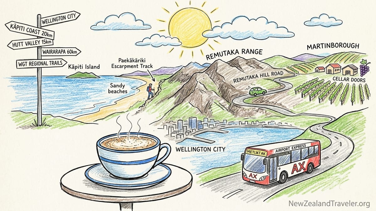
I used Metlink’s Airport Express, the AX, to get between the airport and the city. The practical detail that helped me most was that the Airport Express is a flat-fare service, so I did not have to tag off when I got off the bus. It is also one of the few public-transport pieces in Wellington that is set up for card payments in a straightforward way, which made it feel more like arriving in a big city with modern tap-and-go habits and less like a scavenger hunt for a ticket machine.
My first afternoon played out on foot, because Wellington rewards walking almost immediately. I walked the waterfront with that sideways wind in my ears, then ducked into a cafe when it became clear I could either fight the gusts or enjoy them as part of the city’s personality. That first flat white set the tone: Wellington’s reputation for coffee is not marketing, and it is one of the easiest pleasures to build into every day here. I kept my plans loose, but I also started noting how quickly the city’s compactness can trick you into underestimating the rest of the region.
The Moment I Realized “Wellington” Meant Much More Than The CBD
The shift happened when I began looking at a map with realistic travel times rather than tourist-brochure distances. Within the wider visitor region, WellingtonNZ treats places like the Hutt Valley and Kāpiti Coast as part of the same overall story, not separate add-ons. That framing matched what I was already feeling on the ground. Wellington City was a great base, but the day-trip radius pulled in multiple directions at once, and each direction felt like its own distinct mini-destination.
I also started planning around the trail network, because the outdoors here is not a side quest. Wellington Regional Trails is promoted as covering nearly 300 kilometres across a huge footprint of public land, which helped me understand why the region feels bigger than the city. Once you have a trail map open in one tab and a train timetable in another, you begin thinking in overnights instead of quick hops.
That was when my schedule became too ambitious. I tried to mentally stack a city museum morning, a coastal walk, and a wine-country afternoon into one day and it looked plausible on paper. In reality, Wellington’s hills, wind, and the simple friction of moving between neighborhoods meant I had to admit something: if I wanted the region, I had to give it nights, not just hours.
Getting Around For Real: Trains, Rail Replacements, And When I Chose A Rental Car
I used Wellington Railway Station as my anchor point for regional planning. It is the kind of station where you can step off a train and immediately feel connected to the city on foot, which is not always true in other places. Metlink’s network made it realistic to shape days around rail lines, but I also learned quickly to check service notices before I committed to a plan. Planned rail closures and buses replacing trains are part of life here, and Metlink is explicit that rail-replacement buses operate from a specific platform at Wellington Station, which is exactly the kind of detail you want to know before you arrive hauling a daypack.
For the Wairarapa, I weighed the Wairarapa Connection train against driving. The train is absolutely part of the experience, but my trip tipped toward renting a car because I wanted to control timing for cellar doors and because I knew I would be crossing the Remutaka Range. That road is not just a line on a map. It is a winding climb where weather and closures can matter, and it can be the difference between a relaxed lunch booking and showing up flustered and late.
I still used public transport for segments where it made sense. The biggest realism check I can offer is to never assume a rail plan is plug-and-play on weekends and holidays. The day I nearly overcommitted, I caught myself trying to coordinate a coast walk with a train timetable without building in any buffer. If you are visiting, treat your transport plan like you would in any windy coastal city: confirm it, then give it slack.
Over The Remutaka Range Into Wairarapa: Driving Reality, Road Closures, And Why Martinborough Deserved An Overnight
The drive over the Remutaka Hill Road was the moment the region felt cinematic. The climb out of the Hutt Valley into the range is steady, then it tightens. Corners sharpen, the horizon drops away, and you start understanding why this crossing can shape an entire day. Wind can show up here, too, and I drove it with both hands engaged and no appetite for rushing. If you are planning to drive this route, it matters that NZ Transport Agency Waka Kotahi runs overnight closures for maintenance from January to November each year, with specific closure windows posted through to November 2026. The key takeaway is simple: do not assume you can make a late-night return over the hill without checking whether the road is closed.
I had initially planned Martinborough as a day trip. That was my mistake. The village is set up for tasting-room wandering, slow lunches, and the kind of unplanned stops that are the whole point of wine country. Once I arrived, I realized an overnight would let me treat the day like a holiday instead of a timed exam. It also would have made it easier to build in nearby towns without feeling like I was always watching the clock.
What helped me most was locking in just one or two key winery targets and letting the rest of the afternoon unfold. In Martinborough, cellar doors can run on specific hours and seasonal patterns. Moy Hall, for example, posts reduced May to September hours and is closed midweek. Palliser Estate’s Martinborough cellar door and kitchen are positioned as a full experience with bookings encouraged for groups. The point is not to memorize every timetable. The point is to plan like a human: pick your priorities and then confirm opening hours before you drive across a range for a tasting you might miss.
If I could redo my Wairarapa portion, I would stay a night in Martinborough. The difference is not just comfort. It changes what you can responsibly do with driving, what you can linger over at lunch, and how the day feels in your body. My most honest note from the road is this: when a place makes you slow down, you are already being told it deserves an overnight.
Kāpiti Coast: Beaches, Big Skies, And Walks That Look Easy Until You Start Climbing
I headed north to the Kāpiti Coast for a completely different rhythm. The coast towns feel like they are built around light and air, with sandy beaches and a horizon line that makes the day feel bigger. WellingtonNZ leans into the Kāpiti story as an easy escape from the city, and that matched my experience. Even a half-day out here can reset you after a few windy, urban days in the capital.
The walk that stayed with me most was the Paekākāriki Escarpment Track. It is often described as around 10 kilometres with huge views, and those views are not exaggerated. But the part that surprised me is how much of the effort is front-loaded. You gain height quickly, and on a windy day it can feel exposed, even if the trail itself is well-known and well-used. If you plan to do it, pack more water than you think you need, bring layers, and start earlier than you would in a calm inland climate.
My timing reality check here was that “a walk” can dominate your day. Even if the track time is only a few hours, the total excursion time grows once you add trains or driving, pre-walk coffee, post-walk recovery, and the inevitable pause you will take when the coastline opens up below you. I tried to squeeze too much in and ended up choosing: either I could rush the coast or I could let it be the point of the day. The coast won.
Hutt Valley And The Coastal Edges: A Bigger Outdoor Playground Than I Expected
The Hutt Valley surprised me because it felt like Wellington’s outdoor utility room, in the best way. It is where you go when you want space, river paths, and trailheads without needing to commit to a full backcountry mission. WellingtonNZ describes the Remutaka Cycle Trail as a 122-kilometre ride connecting Wellington to Wairarapa, which was another reminder that the region’s “quick outings” can actually be multi-day adventures if you choose to do them end to end.
One of the most practical and satisfying additions to the region recently is the opening of the Ngā Ūranga to Pito-One shared path, part of the Te Ara Tupua project. It gives walkers and cyclists a dedicated connection between Wellington and Lower Hutt that is designed for resilience along a corridor that can be hammered by weather. Even if you are not cycling long distances, it changes the feel of getting between city and valley. It turns what could be a car-dependent stretch into something you can experience at human speed.
I also spent time thinking about sanctuary access and wildlife, because the wider Wellington Region makes it unusually easy to mix city days with native-bird moments. Zealandia is the name that kept coming up in conversations and in planning, and it is close enough to slot in without losing a whole day. I will not pretend I had a checklist of species, but I did have that distinct New Zealand feeling of hearing birdsong in a place that does not feel like a zoo. It felt like a living patch of the country stitched into the city’s orbit.
The other honest note is that the Hutt Valley can look logistically simple because it sits right next to Wellington. But if you are combining it with other region pieces, it still takes time. I had one day where I tried to pair a Hutt Valley trail outing with a Wairarapa plan and I had to back off. The region is close-knit, but it is not small.
The Takeaway: How I Would Plan A Wider Wellington Region Itinerary Now
If you come to Wellington thinking it is a compact capital break, you can absolutely do that. But if you suspect you will want more, I would plan from the beginning as if the region is the destination and the city is your base camp. That shift changes your pace. It encourages you to choose one major regional direction per day rather than triangulating between Kāpiti, the Hutt, and Wairarapa like you are trying to win a contest.
I would also plan around realities that are easy to overlook from afar. Wind is not an anecdote here, it is a daily factor that affects ferry sailings, walks, and how tired you feel after being outdoors. Train plans are strong, but you need to check for planned rail closures and bus replacements before you commit. Road travel over the Remutaka Hill is memorable and manageable, but it is also subject to scheduled overnight closures for maintenance through November 2026, which can catch visitors off guard if they assume highways run like clockwork.
Most importantly, I would assign overnights where the experience naturally slows you down. For me, Martinborough was the clearest overnight call because wine country is built for lingering. The Kāpiti Coast can also earn an overnight if you want unhurried beach time plus a big walk. Wellington City remains the best anchor for evenings, food, and that effortless ability to walk from dinner to waterfront to your hotel. The surprise is not that any of this exists. The surprise is how easily a Wellington trip becomes a wider Wellington Region itinerary the moment you let it.
FAQ
Q1. How many days do I need for the wider Wellington Region, not just Wellington City?
To do Wellington City plus at least two regional areas at a sane pace, I would plan 4 to 6 nights, especially if you want walks and wine without rushing.
Q2. What is the simplest way to get from Wellington Airport to the city without a car?
I used the Metlink Airport Express (AX). It is a flat-fare service and you do not need to tag off when you exit, which makes arrival day easier.
Q3. Should I rely on trains for day trips to the Kāpiti Coast and Hutt Valley?
Yes, trains can work well, but I learned to always check Metlink notices for planned rail closures and buses replacing trains, especially around weekends and holidays.
Q4. Is it worth renting a car for Wairarapa and Martinborough?
For me, yes, because it gave me control over cellar door timing and made it easier to shape the day around the Remutaka crossing. If you drink, plan tastings responsibly and consider staying overnight.
Q5. What surprised you most about driving over the Remutaka Range?
The road feels like a real mountain crossing rather than a quick hop. It is winding, weather can change quickly, and NZTA schedules overnight closures for maintenance through November 2026.
Q6. Is Martinborough doable as a day trip from Wellington?
It is doable, but my honest take is that it is better with an overnight. The village is built for slow lunches and relaxed tasting-room wandering, which does not pair well with a rushed return drive.
Q7. What is the best big walk on the Kāpiti Coast for dramatic views?
The Paekākāriki Escarpment Track is the classic. It is often described as roughly 10 km and it feels bigger than that when wind is up and the climb hits early.
Q8. Are there meaningful trails and cycling routes close to Wellington City?
Yes. The region promotes an extensive network, and Te Ara Tupua’s Ngā Ūranga to Pito-One section adds a major shared walking and cycling connection toward Lower Hutt.
Q9. Where can I see native birds without leaving the Wellington area?
Zealandia is the obvious choice near the city. It is close enough to fit into a Wellington day without losing the whole schedule.
Q10. What is the single biggest planning mistake to avoid?
Overstuffing days. I tried to combine city time, a major walk, and a wine-country push and it became stressful. Pick one main regional direction per day and build buffer time.